 Filter: Categories of Wisconsin Historical Images
Filter: Subject of Ocean
Filter: Subject of aids to navigation
Filter: Categories of Wisconsin Historical Images
Filter: Subject of Ocean
Filter: Subject of aids to navigation
| Date: | |
|---|---|
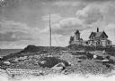
| Description: | Eastern Point Lighthouse at "Mother Ann" and residence on rocky point, Gloucester, Massachusetts. Mother Ann is a rocky cliff at the far south end of Easte... |

| Date: | 1786 |
|---|---|
| Description: | One half of a four sheet nautical chart, showing the coastlines of the north-west hemisphere. The interior lands are left bare, even of basic features such... |

| Date: | 1566 |
|---|---|
| Description: | Map showing the place names, rivers, and mountains of Europe, north-western Africa, the northern half of South America, and North America. Rhumb lines cros... |

| Date: | 1729 |
|---|---|
| Description: | This small and hand-painted map focuses on the English claims in North America along the east coast from Cuba up to the southern tip of Greenland. It shows... |

| Date: | 1733 |
|---|---|
| Description: | This map of North America shows settlements, rivers, lakes, Native American land, trade winds, and numerous topographical features such as forests and moun... |
If you didn't find the material you searched for, our Library Reference Staff can help.
Call our reference desk at 608-264-6535 or email us at: