 Filter: Categories of Wisconsin Historical Images
Filter: Subject of Neighborhoods
Filter: Year of 1800-1899
Filter: Categories of Wisconsin Historical Images
Filter: Subject of Neighborhoods
Filter: Year of 1800-1899

| Date: | 1874 |
|---|---|
| Description: | Stereograph of elevated view looking northwest from Exposition Building. There is a church on a street corner on the left, and the Best Brewing Company in ... |
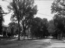
| Date: | 1860 |
|---|---|
| Description: | A view of a tree-lined residential street with houses partially visible on the left. |
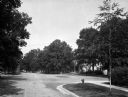
| Date: | 1870 |
|---|---|
| Description: | A view of an intersection of tree-lined streets in a residential area. Homes are partially visible on the right. |

| Date: | 1870 |
|---|---|
| Description: | A view of a tree-lined residential street, with homes partially visible on the right. |
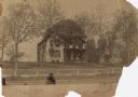
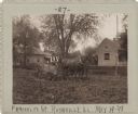
| Date: | 05 14 1887 |
|---|---|
| Description: | The family home of William Henry Rogers on the shore of Lake Mendota. |
| Date: | 1890 |
|---|---|
| Description: | Cigar workers on the sidewalk in front of the Willms home, Milwaukee, Wisconsin. They are young men and older boys, some in aprons. Anna Willms (b. 1881) a... |

| Date: | 1878 |
|---|---|
| Description: | This map shows block numbers, wards, roads, railroads, parks, and selected buildings and includes a "Milwaukee city street guide" as well as a guide to pub... |

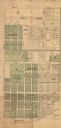
| Date: | 1887 |
|---|---|
| Description: | This map shows block numbers, roads, railroads, wards, and selected buildings. The map includes a "Milwaukee city street guide" and index to public buildin... |
| Date: | 05 19 1898 |
|---|---|
| Description: | Two men sit in a horse-drawn wagon mired in the mud on a dirt road. Several houses are in the background, with two women standing on a porch on the left, i... |

| Date: | 1855 |
|---|---|
| Description: | Pen-and-ink on paper. Includes certifications signed by surveyor and by "John T. Perkins, by his attorney I.A. Lapham." Inscribed and signed certification ... |

| Date: | 1857 |
|---|---|
| Description: | Caption reads: "THE LOTS embraced in the proposed Addition, are situated in the Fourth Ward of the City of Milwaukee, about twenty minutes walk from Spring... |

| Date: | 1858 |
|---|---|
| Description: | Map of Martineau's Addition in the first ward of Milwaukee as well as buildings and location of adjacent additions with landowners names. |
| Date: | 1890 |
|---|---|
| Description: | Map of Merrill Estate property for sale and sold. Map reads: "Merrill Estate property (colored) lots marked X are sold for terms & prices inquire of S.H. C... |
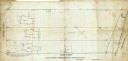
| Date: | 09 1886 |
|---|---|
| Description: | This map shows buildings with dimensions, as well as lot and block corners. Ink on tracing cloth. Oriented with north to the lower right. |

| Date: | 1860 |
|---|---|
| Description: | Map shows meadows, forests, buildings, railroad, and lots south of part of the city of Milwaukee. Relief shown by hachures. Includes list of lot acreages. |
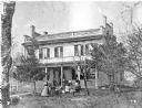
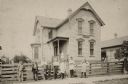
| Date: | 1877 |
|---|---|
| Description: | The Abiel E. Brooks House, built in 1853, with a family group posed on the lawn and porch. Identified (front row, left to right) are Mrs. Noah (Jane Ann) C... |

| Date: | 1863 |
|---|---|
| Description: | This map of Superior shows Montgomery's Addition. An inset map shows the south west end of Lake Superior where Montgomery's Addition is located. The map re... |

| Date: | 1871 |
|---|---|
| Description: | This map of Waukesha shows lot owners, buildings, and various plat additions. The margins of the maps include street reference, a Waukesha business directo... |

| Date: | 1856 |
|---|---|
| Description: | This map of Woodman's Addition in Mineral Point is pen-and-ink on paper. The map includes certifications signed by John B. Whitelaw (surveyor), Cyrus Woodm... |

| Date: | 1836 |
|---|---|
| Description: | This map of Navarino shows a development plat of the village situated opposite Fort Howard at mouth of the Fox River. The names of proprietors are listed a... |
If you didn't find the material you searched for, our Library Reference Staff can help.
Call our reference desk at 608-264-6535 or email us at: