 Filter: Categories of Wisconsin Historical Images
Filter: Subject of Neighborhoods
Filter: County of Milwaukee
Filter: Categories of Wisconsin Historical Images
Filter: Subject of Neighborhoods
Filter: County of Milwaukee

| Date: | 1846 |
|---|---|
| Description: | This map shows lot and block numbers, roads, railroads, and some landowners’ names and includes the manuscript annotations: "From the Lapham collection" --... |

| Date: | 1845 |
|---|---|
| Description: | This map shows lot and block numbers, local streets, railroads, some landowners’ names, Milwaukee River, Menomonee River, and part of Lake Michigan. The ma... |

| Date: | 1846 |
|---|---|
| Description: | This map shows lot and block numbers, local streets, railroads, some landowners’ names, Milwaukee River, Menomonee River, and part of Lake Michigan. The ma... |

| Date: | 1847 |
|---|---|
| Description: | This map shows lot and block numbers, roads, railroads, and some landowners’ names. Lake Michigan, the Milwaukee River, and the Menomonee River are labeled... |

| Date: | 01 12 1963 |
|---|---|
| Description: | Winter scene with teenage boy snow blowing the driveway of a house. His letter jacket has "64" on the sleeve. He is also wearing a stocking cap with pom-po... |

| Date: | 1960 |
|---|---|
| Description: | This blue print map shows village limits, collector residential streets, and primary residential streets. The upper right corner features a key to street t... |

| Date: | 1906 |
|---|---|
| Description: | This map shows ward boundaries, subdivisions, lot and block numbers and dimensions, house numbers, electric car lines, steam railways, and adjoining plat n... |
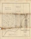
| Date: | 1855 |
|---|---|
| Description: | This map shows plat of town, local streets, numbered blocks and lots, proposed city park, Murray’s addition, and part of Lake Michigan. Also includes a tab... |
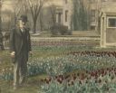
| Date: | 1914 |
|---|---|
| Description: | Frederick Layton gave this hand-colored photograph of himself in his garden on Marshall Street to his niece Elizabeth Layton Fowle on August 8, 1914. He di... |
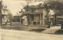
| Date: | |
|---|---|
| Description: | A view across street towards Frederick and Elizabeth Layton's home at 524 Marshall Street. The clapboard house has two porches. On the left is a roofed enc... |

| Date: | 1879 |
|---|---|
| Description: | This map shows wards, sections, roads, lot and block numbers, subdivisions, and proposed streets. The inside cover includes hand written annotations that r... |

| Date: | 1880 |
|---|---|
| Description: | This map shows wards, roads, railroads, lot and block numbers, subdivisions, parks, and some landownership. A handwritten annotation in red reads: "Note: S... |

| Date: | 04 14 1967 |
|---|---|
| Description: | Bernice Lindsay is standing under a new reflected street name sign in her honor. She is wearing a coat, a hat, and a broach. Beside her is a fire hydrant. ... |

| Date: | 04 14 1967 |
|---|---|
| Description: | Vel Phillips is in a dress on a podium. She is next to Bernice Lindsay, who is wearing a coat and a hat. Behind them is Reverend Lovell Johnson, who is wea... |

| Date: | 04 14 1967 |
|---|---|
| Description: | Alderman Martin E. Schreiber, President of the Milwaukee Common Council, is on a podium wearing a suit. On the left is Vel Phillips who is wearing a dress.... |

| Date: | 04 14 1967 |
|---|---|
| Description: | 6th Ward Milwaukee Alderman Vel Phillips is wearing a dress and standing on a podium. To the right are Bernice Lindsay and Reverend Lovell Johnson standing... |

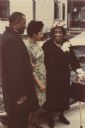
| Date: | 04 14 1967 |
|---|---|
| Description: | Vel Phillips is on a podium wearing a dress. To the left are two members of the media holding recording equipment who are documenting the N Lindsay Street ... |

| Date: | 04 14 1967 |
|---|---|
| Description: | Reverend Lovell Johnson of St. Marks African Methodist Episcopal Church is on a podium in a coat and hat. On her right are Vel Phillips and Bernice Lindsay... |
| Date: | 04 14 1967 |
|---|---|
| Description: | Reverend Lovell Johnson is on the left wearing a coat. On the right is Bernice Lindsay who is wearing a hat and carrying a handbag and cane. In the middle ... |

| Date: | 04 14 1967 |
|---|---|
| Description: | Vel Phillips is behind the podium in a dress. She is reaching out her hand for Bernice Lindsay, who is wearing a coat and a hat. An unidentified person is ... |
If you didn't find the material you searched for, our Library Reference Staff can help.
Call our reference desk at 608-264-6535 or email us at: