 Filter: Categories of Wisconsin Historical Images
Filter: Subject of Neighborhoods
Filter: County of Milwaukee
Filter: Categories of Wisconsin Historical Images
Filter: Subject of Neighborhoods
Filter: County of Milwaukee

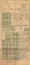
| Date: | 1878 |
|---|---|
| Description: | This map shows block numbers, wards, roads, railroads, parks, and selected buildings and includes a "Milwaukee city street guide" as well as a guide to pub... |

| Date: | 06 01 1937 |
|---|---|
| Description: | Elevated view of a man filling a bucket with coal from a dispenser on the back of an International truck owned by Northwest Side Coal Company. The text on ... |

| Date: | 1939 |
|---|---|
| Description: | A man hoists a bucket of coal onto his shoulder from a chute in the back of an International D-300 truck owned by Co-op Coal. The truck is parked along a r... |

| Date: | 1887 |
|---|---|
| Description: | This map shows block numbers, roads, railroads, wards, and selected buildings. The map includes a "Milwaukee city street guide" and index to public buildin... |

| Date: | 05 18 1939 |
|---|---|
| Description: | Two men standing near the back of an International D-246-F truck outfitted with a cement mixer body. The truck is owned by Tews Lime & Cement Company. |

| Date: | |
|---|---|
| Description: | Stereograph elevated view from the dome of the Milwaukee Exposition Building looking south at the urban landscape. The cyclorama building in the foreground... |

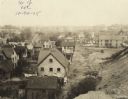
| Date: | |
|---|---|
| Description: | Elevated stereograph of the Trinity Church, surrounded by the rooftops of nearby homes. Text at right: "Milwaukee and Vicinity, Photographed by H.H. Bennet... |

| Date: | 08 14 1968 |
|---|---|
| Description: | A group of children are holding up hand-made signs, demonstrating for "Snoopy for President." Several children are wearing Peanuts t-shirts and sweatshirts... |

| Date: | |
|---|---|
| Description: | Father James Groppi marches with African American teenage girls who are carrying signs that read, "Stop Bussing For Segregation" and "Stop School Segregati... |
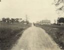
| Date: | 1925 |
|---|---|
| Description: | View down dirt road running through homes and trees in a neighborhood. A man stands in the road. Text at foot of photograph reads, "Toelle Ave. 138+12 Look... |

| Date: | 1855 |
|---|---|
| Description: | Pen-and-ink on paper. Includes certifications signed by surveyor and by "John T. Perkins, by his attorney I.A. Lapham." Inscribed and signed certification ... |

| Date: | 1857 |
|---|---|
| Description: | Caption reads: "THE LOTS embraced in the proposed Addition, are situated in the Fourth Ward of the City of Milwaukee, about twenty minutes walk from Spring... |
| Date: | 10 31 1925 |
|---|---|
| Description: | View of dirt road running through homes and trees in a neighborhood. An automobile is parked in the foreground, at the end of the road. Text at foot of pho... |

| Date: | 1858 |
|---|---|
| Description: | Map of Martineau's Addition in the first ward of Milwaukee as well as buildings and location of adjacent additions with landowners names. |
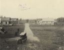
| Date: | 10 30 1925 |
|---|---|
| Description: | Elevated view of alley between houses in a neighborhood from railroad embankment. An elevated bridge is just visible in the far background. Text at foot of... |
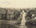
| Date: | 10 30 1925 |
|---|---|
| Description: | Elevated view of street through a neighborhood from a railroad embankment. A truck and driver can be seen in the intersection. An elevated bridge is just v... |
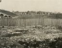
| Date: | 1925 |
|---|---|
| Description: | View of football field and bleachers from railroad embankment. In the foreground is rubble against a wooden fence. In the middle of the football field a nu... |

| Date: | 10 31 1925 |
|---|---|
| Description: | View of dirt road running through trees. A man stands in the road. Some homes can barely be seen in the background beyond the trees. Text at foot of photog... |
| Date: | 1890 |
|---|---|
| Description: | Map of Merrill Estate property for sale and sold. Map reads: "Merrill Estate property (colored) lots marked X are sold for terms & prices inquire of S.H. C... |

| Date: | 1940 |
|---|---|
| Description: | This map is pen and ink on paper and is 1 map consisting of 12 sheets. This map includes a numbered key labeling each area, all of which are represented ... |
If you didn't find the material you searched for, our Library Reference Staff can help.
Call our reference desk at 608-264-6535 or email us at: