 Filter: Categories of Wisconsin Historical Images
Filter: Subject of Mines and mineral resources
Filter: Categories of Wisconsin Historical Images
Filter: Subject of Mines and mineral resources
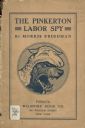
| Date: | 1907 |
|---|---|
| Description: | Cover of the book The Pinkerton Labor Spy by Morris Friedman. The book was a work of non-fiction detailing the use of spies during labor disputes b... |

| Date: | 12 1903 |
|---|---|
| Description: | This manuscript blueprint map shows streets and lots and includes certifications in the left margin. Horizontal streets top to bottom are: Iroquois, Main, ... |

| Date: | 1937 |
|---|---|
| Description: | Pictorial map showing historical events and locations within the state of Wisconsin, as well as waterways and counties. Original caption on the bottom marg... |

| Date: | 1985 |
|---|---|
| Description: | This map shows mining, White River, Silver Creek, Bad River, Agogic Lake, Chequamegon Bay, smaller lakes, the Bad River Indian Reservation, and communities... |

| Date: | 1864 |
|---|---|
| Description: | This map is pen and watercolor on paper and shows a profile and the geological formation of Blue Mound. Also shown is the location of Arnold's Hotel and Br... |

| Date: | 1903 |
|---|---|
| Description: | This blue line print shows quartzite areas, mines, railroads, and roads. The map covers townships 11-13 north, ranges 4-8 east, in parts of Sauk and Columb... |

| Date: | 1904 |
|---|---|
| Description: | This blue line print map includes 4 cross sections with relief shown by contours and spot heights. The topography was taken from the United States Geologic... |

| Date: | |
|---|---|
| Description: | Original caption reads: "TD-24 Torque Converter Tractor push loads a 24 and B-250 27 /12 hd. scraper combination in hard fire clay whilst a gear driven-24 ... |

| Date: | |
|---|---|
| Description: | A vintage view and a modern view of the zinc works site, presented as a pair. Views include industrial buildings and snow. |
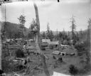
| Date: | 1903 |
|---|---|
| Description: | Elevated view of a mining camp in the western United States. At this time Carl Peterson was writing letters home to Christine Jenson about his journey. |
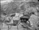
| Date: | 1903 |
|---|---|
| Description: | View down set of two railroad tracks towards four coal miners posing in front of a mine entrance near a coal car. The caption in the book reads, "Strike-br... |

| Date: | 1922 |
|---|---|
| Description: | Elevated view from hill looking down on a mining town surrounded by wooded hills. There are wooden sidewalks between the houses. In the background on the l... |

| Date: | 1719 |
|---|---|
| Description: | Map of the British colonies and territories in North American, depicting cities, Native American land, rivers, mines, forts, trees, and topography east of ... |

| Date: | 1782 |
|---|---|
| Description: | Map of the West Indies and south eastern North America, remarkably detailed, showing cities, mountains, rivers, lakes, mines, plantations, forts, banks, an... |

| Date: | 1783 |
|---|---|
| Description: | This map is hand-colored and shows the boundaries of British, Spanish, and the newly recognized American claims, as well as the fishing rights granted to F... |

| Date: | 1866 |
|---|---|
| Description: | A colorful map of Gilpin County, the central gold region of Colorado, surveyed by Charles W. Morse and George Hill. |

| Date: | 1719 |
|---|---|
| Description: | Map of North America showing political boundaries, areas of Indian habitation, cities, towns, ports, rivers, mines, and other notable for North America fro... |

| Date: | 1745 |
|---|---|
| Description: | Landmark map of the Great Lakes region and one of the most advanced depictions of the lakes and surrounding areas for its time. It is the first map to intr... |

| Date: | 1720 |
|---|---|
| Description: | Map of North America from from the Rio Grande to the Atlantic Ocean, showing boundaries, the colonies, cities, settlements, mines, forts, Native American l... |

| Date: | 1765 |
|---|---|
| Description: | Detailed map composed for the London Magazine of the Mississippi River Valley at the conclusion of the French and Indian War. The British colonies themselv... |
If you didn't find the material you searched for, our Library Reference Staff can help.
Call our reference desk at 608-264-6535 or email us at: