 Filter: Categories of Wisconsin Historical Images
Filter: Subject of Menominee Indians
Filter: Reproduction Rights of For Sale
Filter: Categories of Wisconsin Historical Images
Filter: Subject of Menominee Indians
Filter: Reproduction Rights of For Sale

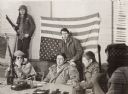
| Date: | 1975 |
|---|---|
| Description: | Actor Marlon Brando (center) and Father James Groppi of Milwaukee arrive at the Alexian Novitiate in Gresham. The building had been seized by members of th... |
| Date: | 01 18 1975 |
|---|---|
| Description: | Negotiations between leaders of the Menominee Warrior Society and the American Indian Movement with General Hugh Simonson (in the Army jacket) of the Wisco... |
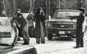
| Date: | 1975 |
|---|---|
| Description: | An unidentified member of the Wisconsin State Patrol points his revolver at several Native Americans at a vehicle checkpoint near Gresham. The State Patrol... |

| Date: | 1938 |
|---|---|
| Description: | This map shows lakes, rivers, roads, trails, lookout towers, and railroads. |

| Date: | |
|---|---|
| Description: | Billhead of the Oshkosh Brewing Company, in business from 1894-1971, with the company trademark of a waist-up view of Chief Oshkosh wearing a jacket and bo... |

| Date: | |
|---|---|
| Description: | Letterhead of the Oshkosh Brewing Company, active from 1894-1971, with the company trademark of a waist-up view of Chief Oshkosh wearing a jacket, a banded... |

| Date: | 1846 |
|---|---|
| Description: | A map of Wisconsin and a portion of Minnesota that show the township surveys in progress in portions of the Saint Croix River region and in central Wiscons... |

| Date: | 1848 |
|---|---|
| Description: | Map of Wisconsin and a portion of Minnesota showing the township surveys in progress in portions of the Saint Croix River region and in central Wisconsin a... |

| Date: | 1857 |
|---|---|
| Description: | A map of the state of Wisconsin and the southeastern portion of the Territory of Minnesota, showing the Wisconsin reservations of the Oneida, Menominee, St... |

| Date: | 1858 |
|---|---|
| Description: | A survey map that shows the status of township surveys in Wisconsin. At that point, the majority of the state had been surveyed and platted, with the area... |

| Date: | 1860 |
|---|---|
| Description: | A survey map of Wisconsin, southeastern Minnesota, and northern Iowa, showing the status of surveys, rivers, and lakes. The map also shows the locations of... |
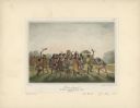
| Date: | 1842 |
|---|---|
| Description: | Menominee war dance, as depicted by Francois, Comte de Castelnau, a French naturalist and diplomat who visited Green Bay, Wisconsin about 1838. This detail... |
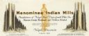
| Date: | |
|---|---|
| Description: | Letterhead of Menominee Indian Mills of Neopit, Wisconsin, a mill "under supervision of the United States Department of the Interior, Office of Indian Affa... |

| Date: | 1979 |
|---|---|
| Description: | A map of Southern Wisconsin and northern Illinois showing the areas inhabited by the Ho-Chuck, formerly known as the Winnebago. Some of the location names ... |
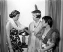
| Date: | 05 25 1956 |
|---|---|
| Description: | Attending the YWCA Benefit Tea for internationally speaking foreign students in costume of their native land are, left to right: Judith Ahana, Honolulu Haw... |

| Date: | 1855 |
|---|---|
| Description: | This map shows the entire state and part of the Upper Peninsula of Michigan. It depicts creeks, rivers, lakes, railroads completed, railroads in progress, ... |

| Date: | 1855 |
|---|---|
| Description: | This Wisconsin map depicts counties, creeks, rivers, lakes, railroads completed, railroads in progress, common roads and the Menomonee Reservation. |

| Date: | 1855 |
|---|---|
| Description: | This map depicts counties, creeks, rivers, lakes, railroads completed, railroads in progress, common roads and the Menomonee Reservation. |

| Date: | 1941 |
|---|---|
| Description: | Wisconsin counties, towns, cities, and selected villages, as well as the Menominee Indian Reservation are identified on this U.S. Bureau of the Census map ... |

| Date: | 1952 |
|---|---|
| Description: | This map shows counties, towns, cities, and selected villages, as well as the Menominee Indian Reservation are identified on this U.S. Post Office. Circles... |
If you didn't find the material you searched for, our Library Reference Staff can help.
Call our reference desk at 608-264-6535 or email us at: