 Filter: Categories of Wisconsin Historical Images
Filter: Subject of Men
Filter: Subject of coasts
Filter: Categories of Wisconsin Historical Images
Filter: Subject of Men
Filter: Subject of coasts
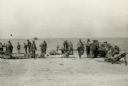
| Date: | 11 13 1942 |
|---|---|
| Description: | Headquarters of the 32nd American Division, on the beach at Pongani, northeast New Guinea. |
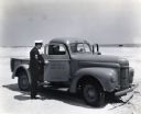
| Date: | 1943 |
|---|---|
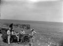
| Description: | Two uniformed men sit inside an International K-1 U.S. Coast Guard truck parked on a beach while another man speaks to them through the open passenger door... |
| Date: | |
|---|---|
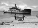
| Description: | View from shoreline toward the wreck of the S.S. Atlantus, a concrete hulled ship in the water near a shoreline. In the foreground are three men on ... |
| Date: | |
|---|---|
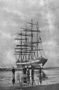
| Description: | A bark, the "Galena," stranded on Clatsop Beach, with three men and two women on the beach in the foreground. |
| Date: | |
|---|---|
| Description: | View of a stained glass window erected in 1920 in honor of the women of Plymouth Plantation. On the center panel, a ship is in the bay while a man and wom... |
| Date: | |
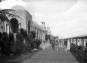
|---|---|
| Description: | People walk along the Casino Walk promenade between a row of buildings and a beach. Beside the beach is a covered sitting area set with folding chairs. |
| Date: | |
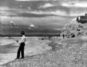
|---|---|
| Description: | View of men surf fishing along a rocky shoreline at Point State Park. |
| Date: | |
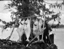
|---|---|
| Description: | A fishermen smoking a pipe poses with fish strung from a wooden pole beneath an evergreen tree. |
| Date: | |
|---|---|
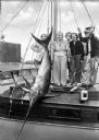
| Description: | Fishermen and women pose with a swordfish tied to a mast aboard a boat. |
| Date: | |
|---|---|
| Description: | A couple walks along a sandy shoreline. Dwellings and buildings are visible in the background. |

| Date: | |
|---|---|
| Description: | Elevated view of Bermuda shoreline. Several dwellings stand on top of the island and people swim in the ocean on the beaches below. |

| Date: | |
|---|---|
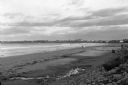
| Description: | People stand and sit on a driftwood-cluttered beach. Several people swim in the ocean. Caption reads: "Scene on the Beach. Long Beach. Wash." |
| Date: | 1945 |
|---|---|
| Description: | Leota Kelly, directer of the Pacific Athletic Club, division of the Red Cross, and colleagues, at the site of the new Red Cross Club in Tinian near a cliff... |

| Date: | 1990 |
|---|---|
| Description: | Color photo of an International school bus driven along a coastal road. In the foreground is a split-rail fence and lawn. The photograph was probably taken... |

| Date: | 1968 |
|---|---|
| Description: | Three-quarter view from front of passenger side of red International Scout with white Traveltop. Two people are in the front seat. The sides of the Travelt... |

| Date: | 1690 |
|---|---|
| Description: | A mysterious mixture of mythology, ancient geography, and late 17th century knowledge of the American coastline. This map shows North and South America, bu... |

| Date: | 1759 |
|---|---|
| Description: | Map of north eastern Canada and parts of New England, showing settlements, cities, portages, Native American land, mountains, lakes, and rivers. The unusua... |

| Date: | 1667 |
|---|---|
| Description: | Map of Virginia depicting the discoveries detailed by John Smith in his exploration of the region. It shows Jamestown, Native American tribes and villages,... |

| Date: | 1671 |
|---|---|
| Description: | Map of Virginia depicting the discoveries detailed by John Smith in his exploration of the region. It shows Jamestown, Native American tribes and villages,... |

| Date: | 1761 |
|---|---|
| Description: | Map covering southern Louisiana from Lake Ponchetrain to the Golf of Mexico and from Woods Bay in the west to the islands just east of Bay St. Louis. It sh... |
If you didn't find the material you searched for, our Library Reference Staff can help.
Call our reference desk at 608-264-6535 or email us at: