 Filter: Categories of Wisconsin Historical Images
Filter: Subject of Marshes
Filter: Subject of indians of north america
Filter: Categories of Wisconsin Historical Images
Filter: Subject of Marshes
Filter: Subject of indians of north america
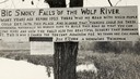
| Date: | 1920 |
|---|---|
| Description: | Sign for the toll road at Big Smoky Falls on the Wolf River. The sign reads: "Big Smoky Falls of the Wolf River. Many years ago before 1925 there was no ro... |

| Date: | |
|---|---|
| Description: | A man wearing a hat, possibly Ho-Chunk, is mounted bareback on a horse knee-deep in water in a marsh. |
| Date: | |
|---|---|
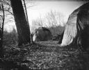
| Description: | Ho-Chunk lodges among trees. Probably a Ho-Chunk encampment at the cranberry marsh. |

| Date: | |
|---|---|
| Description: | Ho-Chunk winter lodges among trees, probably a Ho-Chunk encampment at the cranberry marsh. There are large, cut logs in between two lodges. A small Ho-Chun... |
| Date: | |
|---|---|
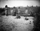
| Description: | Standing together in a row are two Ho-Chunk girls wearing print dresses, and two Ho-Chunk boys who are nude on a sandy pile in front of a marsh. In front o... |

| Date: | 1847 |
|---|---|
| Description: | A hand-colored map that shows the area south and east of the Wisconsin and Fox Rivers, as well as a few landmarks just north of that area. The township gri... |

| Date: | 1856 |
|---|---|
| Description: | This map with an ornamental border shows the township survey grid and identifies counties, named towns, cities and villages, rivers, lakes, railroads, road... |

| Date: | 1856 |
|---|---|
| Description: | This map of shows the township survey grid and identifies counties, named towns, cities and villages, rivers, lakes, railroads, roads, and the Menomonee an... |

| Date: | 1857 |
|---|---|
| Description: | This map depicts the township survey grid and identifies counties, named towns, cities and villages, rivers, lakes, railroads, roads, and the Menomonee and... |

| Date: | 1858 |
|---|---|
| Description: | This map of the entire state of Wisconsin depicts the township survey grid and identifies counties, named towns, cities and villages, rivers, lakes, railro... |

| Date: | 1859 |
|---|---|
| Description: | This map of the entire state of Wisconsin depicts the township survey grid and identifies counties, named towns, cities and villages, rivers, lakes, railro... |

| Date: | 1864 |
|---|---|
| Description: | This map of the entire state of Wisconsin depicts the township survey grid and identifies counties, named towns, cities and villages, rivers, lakes, railro... |

| Date: | 1865 |
|---|---|
| Description: | This map of the entire state of Wisconsin depicts the township survey grid and identifies counties, named towns, cities and villages, rivers, lakes, railro... |

| Date: | 1871 |
|---|---|
| Description: | This map of Wisconsin and surrounding states depicts the township survey grid and identifies counties, named towns, cities and villages, rivers, lakes, rai... |

| Date: | 1874 |
|---|---|
| Description: | This hand-colored map shows the railroads "completed" "in progress" and "contemplated" rivers, counties, cities and villages, and named towns in the state,... |

| Date: | |
|---|---|
| Description: | A map of the Wisconsin counties of Lincoln, Oneida, Vilas, parts of Iron, Price & Langlade that shows the township and range grid, sections, villages, rai... |

| Date: | 1974 |
|---|---|
| Description: | This 1968 map identifies resorts in the Lac du Flambeau Indian Reservation region of Wisconsin, covering parts of Iron, Vilas, Oneida, and Price counties. ... |

| Date: | 1800 |
|---|---|
| Description: | This map is pencil on tracing paper and shows marshes, the Wisconsin River, Indian trails, and Indian boundary line. The upper left corner reads: "Let sect... |

| Date: | 1930 |
|---|---|
| Description: | Original map made with watercolor and inkwash. Includes a legend of buildings, roads, natural features and other details of the lodge. Inset at bottom has ... |

| Date: | |
|---|---|
| Description: | View across water of a Menominee man standing in a canoe in a marsh. He is holding a paddle in his hand. Behind him on the left is another canoe with three... |
If you didn't find the material you searched for, our Library Reference Staff can help.
Call our reference desk at 608-264-6535 or email us at: