 Filter: Categories of Wisconsin Historical Images
Filter: Subject of Marshes
Filter: Subject of flowers
Filter: Categories of Wisconsin Historical Images
Filter: Subject of Marshes
Filter: Subject of flowers
| Date: | |
|---|---|
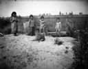
| Description: | Standing together in a row are two Ho-Chunk girls wearing print dresses, and two Ho-Chunk boys who are nude on a sandy pile in front of a marsh. In front o... |

| Date: | 1795 |
|---|---|
| Description: | Map of Connecticut showing counties, townships, cities, roads, islands, swamps, hills, mountains, lakes, rivers, reefs, and numerous other geographical and... |

| Date: | 1784 |
|---|---|
| Description: | Map of the southeastern region of America to just west of the Mississippi River. It shows borders, cities, towns, forts, Native American land, portages, mo... |

| Date: | 1776 |
|---|---|
| Description: | Map of Virginia and parts of Maryland and Delaware (written "De La War"). It shows borders, counties, cities, towns, plantations (marked by landowners name... |

| Date: | 1761 |
|---|---|
| Description: | Map covering southern Louisiana from Lake Ponchetrain to the Golf of Mexico and from Woods Bay in the west to the islands just east of Bay St. Louis. It sh... |

| Date: | 08 10 1957 |
|---|---|
| Description: | Unidentified man taking a picture of the Lotus Bed on Lake Mendota. The bed of large, floating white blossoms are at the peak of their bloom. |
| Date: | |
|---|---|
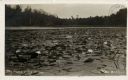
| Description: | View of water lilies and lily pads in a river. Caption reads: "The Home of the Muskie." |
If you didn't find the material you searched for, our Library Reference Staff can help.
Call our reference desk at 608-264-6535 or email us at: