 Filter: Categories of Wisconsin Historical Images
Filter: Subject of Maps
Filter: Subject of writing
Filter: Categories of Wisconsin Historical Images
Filter: Subject of Maps
Filter: Subject of writing
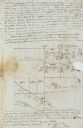
| Date: | 11 26 1846 |
|---|---|
| Description: | A drawing by Thomas Steel of his farm property contained in a letter Steel wrote to his father James Steel. |
| Date: | |
|---|---|
| Description: | Drawn map of Landsford, South Carolina, from Thomas Sumter Papers. |
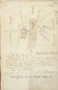
| Date: | 07 04 1776 |
|---|---|
| Description: | Notes written in red ink on the back of the map of the Battle of Black's Fort. |
| Date: | |
|---|---|
| Description: | Display of student work including drawings, maps, and essays. |
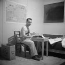
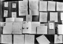
| Date: | 04 16 1945 |
|---|---|
| Description: | Robert Doyle (shirtles), works at the typewriter in his quarters in the BOQ (Bachelor Officer Quarters) #5, room 110, at CINCPAC (Commander in Chief, Pacif... |

| Date: | 1776 |
|---|---|
| Description: | This was one of the first maps available for the general British populace featuring America during the Revolutionary War. It includes forts, cities, topogr... |

| Date: | 1769 |
|---|---|
| Description: | Double hemispherical map showing the continents, islands, countries, and a few major cities of the world. The routes of a few explorers are depicted and la... |

| Date: | 1780 |
|---|---|
| Description: | Map of North and South America, showing the boundaries of colonial territories, cities, settlements, rivers, lakes, and Native American land. Particular em... |

| Date: | 1747 |
|---|---|
| Description: | Map of America showing rivers, lakes, mountains, and regions, but primarily focusing on the French and Native American settlements along the Mississippi th... |

| Date: | 1758 |
|---|---|
| Description: | Map showing lakes, rivers, cities, Native American land, and the boundaries of French and English claims in America and Canada north of New York. A title c... |

| Date: | 1762 |
|---|---|
| Description: | Map including the land and islands surrounding the Gulf of Mexico. The regions and islands are labeled, as are a few rivers and cities. This map was engrav... |
If you didn't find the material you searched for, our Library Reference Staff can help.
Call our reference desk at 608-264-6535 or email us at: