 Filter: Categories of Wisconsin Historical Images
Filter: Subject of Maps
Filter: Subject of ocean
Filter: Categories of Wisconsin Historical Images
Filter: Subject of Maps
Filter: Subject of ocean

| Date: | 1938 |
|---|---|
| Description: | A colorful pictorial map of Australia, featured on the front and back cover of a special Australian edition of International Trail. |

| Date: | |
|---|---|
| Description: | Hand-drawn map of the area at the time of Pilgrim landing, drawn by Charles Blaskowikz. Includes commemorative historical notes. |

| Date: | 07 1941 |
|---|---|
| Description: | Advertising proof for International trucks, featuring color illustrations of a truck and the United States, largely in red, white and blue. Includes the te... |

| Date: | 1932 |
|---|---|
| Description: | Map of the Middle East accompanying an article on International's involvement in building the Iraq Pipe Line. Headline text on the page reads: "Internation... |

| Date: | 1952 |
|---|---|
| Description: | Map of the barley-growing regions of North America, published by the Rahr Malting Company, Manitowoc, Wisconsin, 1952. |

| Date: | 1953 |
|---|---|
| Description: | Front and back of one-page menu from the Scandia Restaurant, with a whimsical cartoon map rendering by Hakon Mielche of the Scandinavian countries and the ... |

| Date: | 07 21 1951 |
|---|---|
| Description: | Luncheon menu for the S.S. Argentina, with a map of Argentina with spot illustrations for the provinces and featured products or symbols, the coat o... |
| Date: | 1950 |
|---|---|
| Description: | Export map for International Harvester products manufactured in Australia at the company's Geelong and Dandenong Works. |

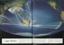
| Date: | 1950 |
|---|---|
| Description: | Inside spread illustration of the world, with a legend indicating: Subsidiary Company, Branch of Subsidiary, Representative, Works, and Distributor. |

| Date: | 1878 |
|---|---|
| Description: | This lithograph shows Greenland, North America, Central America, South America, Polynesia, Australia, the Pacific Ocean, the Atlantic Ocean, the Arctic Oce... |

| Date: | 1878 |
|---|---|
| Description: | This lithograph shows Africa, Europe, Asia, Australia, and the Antarctic Continent, the Atlantic Ocean, the Indian Ocean, the Arctic Ocean, the Pacific Oce... |

| Date: | 1715 |
|---|---|
| Description: | A map of the countries and islands surrounding the Gulf of Mexico. The hand-colored borders separate the territories of England, France, Spain, and Holland... |

| Date: | 1721 |
|---|---|
| Description: | A map of North and South America with an elaborately illustrated cartouche depicting Native Americans in upper left corner. The map is fairly detailed, dep... |

| Date: | 1735 |
|---|---|
| Description: | A map of the western hemisphere, including parts of western Europe and Africa. Portraits of explorers, such as Jacques Marquette, Louis Joliet, and Robert ... |

| Date: | 1739 |
|---|---|
| Description: | This map shows the territorial claims of the western hemisphere by the European powers, as well as the names of major cities, geographical features, and pa... |

| Date: | 1746 |
|---|---|
| Description: | A map of the western hemisphere, including parts of western Europe and Africa, showing the division of the Americas by the European powers. Weapons and fol... |

| Date: | 1786 |
|---|---|
| Description: | This map is an updated version of d'Anville's 1761 map of the western hemisphere. He included more details to the north west coast of North America, partic... |

| Date: | 1703 |
|---|---|
| Description: | Map of the Golf of Mexico and surrounding countries from the Great Lakes down to the northern most parts of South America. L'Isle labels cities, towns, and... |

| Date: | 1720 |
|---|---|
| Description: | One of Herman Moll's most famous maps, often referred to as The Beaver Map for its elaborate engraved inset depicting and describing beavers building a dam... |

| Date: | 1715 |
|---|---|
| Description: | One of Herman Moll's most famous maps, often referred to as The Codfish Map, it shows rivers and portages, cities, Indian villages, wind directions, routes... |
If you didn't find the material you searched for, our Library Reference Staff can help.
Call our reference desk at 608-264-6535 or email us at: