 Filter: Categories of Wisconsin Historical Images
Filter: Subject of Land
Filter: Year of 1800-1899
Filter: Community of Madison
Filter: Categories of Wisconsin Historical Images
Filter: Subject of Land
Filter: Year of 1800-1899
Filter: Community of Madison
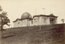
| Date: | 1880 |
|---|---|
| Description: | Exterior of Washburn Observatory at the University of Wisconsin-Madison, showing telephone wires. |
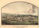
| Date: | 05 1864 |
|---|---|
| Description: | Lithograph of Camp Randall, where the majority of Wisconsin's soldiers were trained and mustered into the Union Army. This view, which was taken from Basc... |

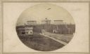
| Date: | 1862 |
|---|---|
| Description: | Camp Randall looking southwest. In April 1861, Governor Alexander Randall asked that the State Agricultural Society fairgrounds be converted into a militar... |
| Date: | 1865 |
|---|---|
| Description: | University of Wisconsin-Madison campus showing the first three buildings on campus, South Hall (left), University Hall [Bascom Hall] (center), and North Ha... |

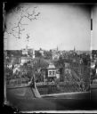
| Date: | 1898 |
|---|---|
| Description: | University Heights from the Chemistry Building on University Avenue. View includes the University of Wisconsin-Madison football field, on the former site o... |
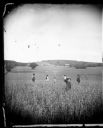
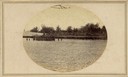
| Date: | 1879 |
|---|---|
| Description: | Five men, facing away from the camera, are standing in a field. Some of them are holding a rakes and a scythe. A boy is in the foreground facing the camera... |

| Date: | 1893 |
|---|---|
| Description: | Back of painting reads: "Madison in June 1837 after photo taken by E.E. Bailey" and "Peck's cabin by Dengel." The Eben Peck cabin was the first house built... |

| Date: | 06 1837 |
|---|---|
| Description: | Lithograph based on a painting by Mrs. E.E. Bailey showing the Peck cabin, the first house in Madison. In addition to the cabin, the lithograph includes a ... |
| Date: | 1861 |
|---|---|
| Description: | Soldiers in formation at Camp Randall during winter. The season [there appears to be snow on the ground] and the tents indicate that this image was made in... |

| Date: | 1851 |
|---|---|
| Description: | Plat map of the Town of Madison (Township 7N, Range 9E), from Volume 4, Federal Survey Plat Books. |

| Date: | 1861 |
|---|---|
| Description: | Drawn the first year of the Civil War, this colored 1861 map of Dane County shows its towns, cities and lakes. It includes insets of the wards of Madison a... |

| Date: | 1839 |
|---|---|
| Description: | A map of the Wiskonsin [sic] and Neenah or Fox Rivers. |

| Date: | 1897 |
|---|---|
| Description: | A view from the capitol looking west up State Street toward the University of Wisconsin-Madison with the Holy Redeemer Church, Holy Redeemer School, Red Gy... |

| Date: | 1879 |
|---|---|
| Description: | Bird's-eye view of Wisconsin State University, now the University of Wisconsin-Madison. Vignettes include Ladies Hall, South Dormitory, University Hall, As... |

| Date: | 1885 |
|---|---|
| Description: | Bird's-eye map of Madison, State Capital of Wisconsin, County Seat of Dane County, with inset of the Wisconsin State Capitol. |

| Date: | 1852 |
|---|---|
| Description: | Pencil drawing of Madison landscape as seen from University Hill. The main street in the center is State Street, and the building with Greek columns in the... |

| Date: | 1852 |
|---|---|
| Description: | Pencil drawing of view overlooking Madison. The sketch looks down North Hamilton Street from the capitol. Rutted, irregular streets and frame houses mark ... |

| Date: | 1836 |
|---|---|
| Description: | The top map is the "Plat of Madison the Capitol of Wisconsin." The bottom map is the "Map of the Four Lake Country. Taken from the Township Maps in the U.S... |
| Date: | 1873 |
|---|---|
| Description: | View, ca. 1873-1879, of Madison looking down Wisconsin Avenue toward the third Wisconsin Capitol, a view that suggests something of the ongoing importance ... |

| Date: | 1855 |
|---|---|
| Description: | Part of George Harrison's "Map of the City of Madison," showing the development of the isthmus and the small size of the second Capitol (54' x 104') in com... |
If you didn't find the material you searched for, our Library Reference Staff can help.
Call our reference desk at 608-264-6535 or email us at: