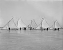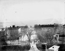
| Date: | 1896 |
|---|---|
| Description: | A gathering of iceboats and their captains on Lake Mendota. |

| Date: | 1894 |
|---|---|
| Description: | Man in a rowboat on Lake Monona with a view of the city in the background. |

| Date: | 1893 |
|---|---|
| Description: | Back of painting reads: "Madison in June 1837 after photo taken by E.E. Bailey" and "Peck's cabin by Dengel." The Eben Peck cabin was the first house built... |

| Date: | 04 24 1899 |
|---|---|
| Description: | Partial view of a boathouse at the foot of North Carroll Street, designed by Frank Lloyd Wright and built for the city of Madison. The University of Wiscon... |

| Date: | 1899 |
|---|---|
| Description: | View along shoreline of University of Wisconsin-Madison buildings across Lake Mendota from Carroll Street. The Armory (Red Gym or Old Red), a boathouse, an... |

| Date: | 1897 |
|---|---|
| Description: | A view from the capitol looking west up State Street toward the University of Wisconsin-Madison with the Holy Redeemer Church, Holy Redeemer School, Red Gy... |

| Date: | 1890 |
|---|---|
| Description: | Looking south from the capitol dome of the Wisconsin State Capitol, the view is of West Main Street bound by South Hamilton Street and Monona Avenue (now M... |

| Date: | 1890 |
|---|---|
| Description: | Bird's-eye view of Superior, Wisconsin. |

| Date: | 1892 |
|---|---|
| Description: | Color bird's-eye map of Wauwatosa, looking east toward Milwaukee and Lake Michigan. Predominantly green with cream colored roadways, with six land plots ow... |

| Date: | 1891 |
|---|---|
| Description: | Bird's-eye view of Eau Claire. |

| Date: | 1898 |
|---|---|
| Description: | Bird's-eye map, looking west from shoreline on Lake Michigan of Milwaukee to Golden Lake in Waukesha County, with Kenosha and Fox Point at bottom corners, ... |

| Date: | 1893 |
|---|---|
| Description: | Bird's-eye map of Superior. Looking from the point, with Superior Bay on left, St. Louis Bay on right, below St. Louis River. |

| Date: | 1890 |
|---|---|
| Description: | Colored bird's-eye map of Oconomowoc and the Lake Region, Waukesha County. Looking North from Government Hill. Location key below image identifies 24 Hotel... |

| Date: | 1896 |
|---|---|
| Description: | A portion of John B. Heim's map of the Water Works System of Madison showing the size of the third Wisconsin Capitol (228' x 226') in comparison with the C... |

| Date: | 1895 |
|---|---|
| Description: | Elevated view of Lake Geneva with the Lake Geneva steamboat. |

| Date: | 1895 |
|---|---|
| Description: | Attorney Albert G. Zimmerman took this photograph of Monona Avenue, with Lake Monona beyond, from the roof of the Madison Capitol about 1895. Across Main ... |

| Date: | 1890 |
|---|---|
| Description: | Field and trees and water are in the foreground. On the far shoreline are buildings in the town. |
If you didn't find the material you searched for, our Library Reference Staff can help.
Call our reference desk at 608-264-6535 or email us at: