 Filter: Categories of Wisconsin Historical Images
Filter: Subject of Lakes
Filter: Subject of transportation
Filter: Categories of Wisconsin Historical Images
Filter: Subject of Lakes
Filter: Subject of transportation
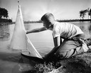
| Date: | 09 08 1956 |
|---|---|
| Description: | A young man launches his toy sailboat in the lagoon. |
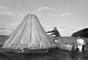
| Date: | 1950 |
|---|---|
| Description: | A man sets up a cone-shaped instrument designed to distill fresh water from salt water as he leans out of a small motor boat on the water. |
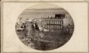
| Date: | 1860 |
|---|---|
| Description: | Intersection of King and East Main streets photographed by John S. Fuller from the Wisconsin State Capitol roof, about 1860-1863. In the foreground two st... |

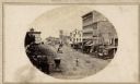
| Date: | |
|---|---|
| Description: | Looking West from Knight Block, with shipping piers and sailing ships on right side, railroad on left, trees in background. Horse-drawn carriages on street... |

| Date: | 1855 |
|---|---|
| Description: | Part of George Harrison's "Map of the City of Madison," showing the development of the isthmus and the small size of the second Capitol (54' x 104') in com... |

| Date: | 1896 |
|---|---|
| Description: | A portion of John B. Heim's map of the Water Works System of Madison showing the size of the third Wisconsin Capitol (228' x 226') in comparison with the C... |
| Date: | |
|---|---|
| Description: | View of Pinckney Street, about 1860, from the roof of the Fairchild Block at the corner of East Main and South Pinckney looking northwest toward Lake Mendo... |
| Date: | 1926 |
|---|---|
| Description: | View of Adams, Tripp and Van Hise Halls. All are residence halls on the University of Wisconsin campus with Picnic Point and Lake Mendota in the backgroun... |

| Date: | 1945 |
|---|---|
| Description: | View of the lower campus of the University of Wisconsin-Madison includes Bascom Hill, Wisconsin Historical Society, Memorial Union and the Armory (Red Gym ... |

| Date: | 1945 |
|---|---|
| Description: | Aerial view of Bascom Hill, Bascom Hall, Wisconsin Historical Society on the University of Wisconsin Madison campus with Lake Mendota on the right. |
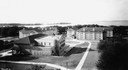
| Date: | 1923 |
|---|---|
| Description: | Aerial view of the University of Wisconsin campus shows from west to east the Agricultural Hall, Observatory Hall and the Wisconsin Historical Society with... |

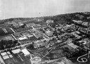
| Date: | 1926 |
|---|---|
| Description: | Originally titled 'Recent Aeroplane View of University Campus', the view of the Wisconsin Historical Society, the Red Gym, Science Hall and Bascom Hall wit... |

| Date: | 1923 |
|---|---|
| Description: | Aerial view of the Wisconsin Historical Society, Science Hall, and Bascom Hall on Bascom Hill on the University of Wisconsin-Madison campus. Lake Mendota i... |
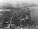
| Date: | 1946 |
|---|---|
| Description: | Aerial view of the University of Wisconsin campus with Lake Mendota on the right. |
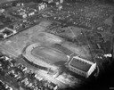
| Date: | 1934 |
|---|---|
| Description: | Aerial view of Camp Randall Stadium and Field House on the University of Wisconsin-Madison campus. |

| Date: | 1908 |
|---|---|
| Description: | Drawing of the general design for future construction development at the University of Wisconsin with the Barn, Sheep Barn, Horse Barn, House, Power House,... |

| Date: | 1908 |
|---|---|
| Description: | General design for future construction development of the University of Madison campus with the general view of the campus by the Architectural commission. |

| Date: | 1910 |
|---|---|
| Description: | Elevated view of Bascom Hill on the University of Wisconsin-Madison campus from the south between the Chemistry Building and Lake Mendota. |
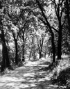
| Date: | 1930 |
|---|---|
| Description: | View of the Lakeshore Path in Bascom Woods by Lake Mendota, later dedicated the Howard M. Temin Lake Shore Path on the University of Wisconsin-Madison camp... |

| Date: | 1956 |
|---|---|
| Description: | Aerial view of lower University of Wisconsin-Madison campus with demolition of buildings on both sides of the Armory-Gymnasium to make space for future pla... |
If you didn't find the material you searched for, our Library Reference Staff can help.
Call our reference desk at 608-264-6535 or email us at: