 Filter: Categories of Wisconsin Historical Images
Filter: Subject of Hats
Filter: Subject of mountains
Filter: Subject of rivers
Filter: Categories of Wisconsin Historical Images
Filter: Subject of Hats
Filter: Subject of mountains
Filter: Subject of rivers
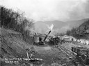
| Date: | 02 22 1919 |
|---|---|
| Description: | Workers using a steam shovel to dig a "borrow pit" for the no. 2 mine. The shovel is loading soil onto a rail car on a narrow gauge railroad track. Benham ... |
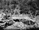
| Date: | 05 03 1919 |
|---|---|
| Description: | Workers building a culvert over Maggard's Branch near mine no. 2. Benham was a "company town" created by International Harvester for the workers employed i... |
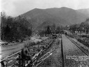
| Date: | 03 29 1919 |
|---|---|
| Description: | Men building a dock along railroad tracks. The tracks run along a stream or small river. Benham was a "company town" created by International Harvester for... |
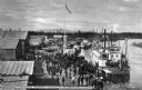
| Date: | |
|---|---|
| Description: | Elevated view of the steamboat "Lavelle Young" landing in Fairbanks as a crowd of people are looking on. Text on photograph reads: "Steamer 'Lavelle Young'... |
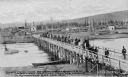
| Date: | 05 20 1905 |
|---|---|
| Description: | Elevated view of a group of miners on horseback crossing a bridge into Fairbanks, Alaska, May 20th, 1905. Houses are on the other side of the river. Captio... |
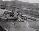
| Date: | 1939 |
|---|---|
| Description: | Elevated view of group of boats and people on shoreline of a river in Peru, with mountains in the background. |
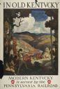
| Date: | 1930 |
|---|---|
| Description: | An original lithograph promoting Kentucky and the Pennsylvania Railroad through an artist's depiction of two men dressed in buckskin, wearing raccoon hats ... |

| Date: | |
|---|---|
| Description: | View of passengers disembarking from a White Pass steamer ship in Dawson, Yukon Territory, Canada. The ship is marked: "Dawson." Piled wood is on the front... |

| Date: | 1864 |
|---|---|
| Description: | View down to valley of Union soldiers posing on the roof of a log building. A log bridge crosses a stream, and many trees are on the hillsides. Plate 05... |

| Date: | |
|---|---|
| Description: | View of a steamboat in the Okanogan River with mountains on the opposite bank. A man in the foreground is sitting in the grass. Caption reads: "Okanogan Ri... |

| Date: | |
|---|---|
| Description: | High, majestic view of "The Narrows" and surrounding cliffs of the Spokane River. A man is balancing on wires over the choppy water. Caption reads: "'The N... |
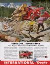
| Date: | 02 1946 |
|---|---|
| Description: | Advertising proof for "rugged" International trucks, featuring a color illustration of men log driving timber down a river with an International truck bear... |
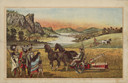
| Date: | 1882 |
|---|---|
| Description: | Back cover of catalog with an illustration of two men using horse-drawn agricultural machinery in fields, while a group of Native American Indians look on.... |

| Date: | 1676 |
|---|---|
| Description: | Detailed map of North and South America. Cities, towns, forests, and mountains are shown pictorially. Duval labels regions, islands, cities, lakes, and Nat... |

| Date: | 1684 |
|---|---|
| Description: | Map of North America showing some colonies, cities, rivers, lakes, and Native American land. Ship routes spread across both oceans, including one decorated... |

| Date: | 1719 |
|---|---|
| Description: | Map of North America showing land divisions between France, Spain, England, Sweden, Denmark and Holland. The map is detailed, labeling cities, forts, islan... |

| Date: | 1770 |
|---|---|
| Description: | Map of North America from the Great Lakes to the northern portion of South America. It shows cities, Native American land, mountains, swamps, lakes, rivers... |

| Date: | 1759 |
|---|---|
| Description: | Map of north eastern Canada and parts of New England, showing settlements, cities, portages, Native American land, mountains, lakes, and rivers. The unusua... |

| Date: | 1784 |
|---|---|
| Description: | Detailed and ornate map of the newly formed United States. The borders of the southern states extend to the Mississippi River, though the states are only c... |

| Date: | 1667 |
|---|---|
| Description: | Map of Virginia depicting the discoveries detailed by John Smith in his exploration of the region. It shows Jamestown, Native American tribes and villages,... |
If you didn't find the material you searched for, our Library Reference Staff can help.
Call our reference desk at 608-264-6535 or email us at: