 Filter: Categories of Wisconsin Historical Images
Filter: Subject of Hats
Filter: Subject of indians of north america
Filter: Subject of rivers
Filter: Categories of Wisconsin Historical Images
Filter: Subject of Hats
Filter: Subject of indians of north america
Filter: Subject of rivers
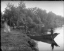
| Date: | 1899 |
|---|---|
| Description: | View along shoreline towards Indian log drivers, two in a bateau, and one man standing on the bank of the Chippewa River. |
| Date: | 1941 |
|---|---|
| Description: | Joe Stoddard of the Chippewa tribe harvesting wild rice on the Bad River Indian Reservation. |
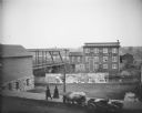
| Date: | |
|---|---|
| Description: | Billboards with advertising for the "Georgia Up-To-Date Minstrels" at the Opera House on Saturday, April 7. Bridge visible to the left. The J.J. McGillivra... |
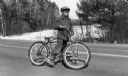
| Date: | 04 1954 |
|---|---|
| Description: | A young Menominee Indian (Charles ?) pauses briefly for a photograph while straddling his bicycle. He is stopped on the road with the snow-covered Wolf Riv... |
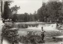
| Date: | 1929 |
|---|---|
| Description: | Group of people at Bear Trap Falls in the Wolf River near Keshena. People are standing on the shoreline on the left near a sign for the falls. A man is sta... |
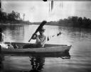
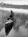
| Date: | |
|---|---|
| Description: | Ho-Chunk man in a canoe on a river holding up an oar. Just out of frame on the left is a woman, who is perhaps holding a child. |

| Date: | 1937 |
|---|---|
| Description: | Label submitted to the state of Wisconsin for trademark registration. "Pioneer Beer, G. Weber Brewing Co." Under this in the center is a leaf with the lett... |
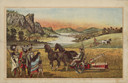
| Date: | 1882 |
|---|---|
| Description: | Back cover of catalog with an illustration of two men using horse-drawn agricultural machinery in fields, while a group of Native American Indians look on.... |

| Date: | 1790 |
|---|---|
| Description: | An updated and corrected version of Robert de Vaugondy's 1750 map "Amérique Septentrionale: Dressée sur les Relations les Plus Modernes des Voyageurs et Na... |

| Date: | 1676 |
|---|---|
| Description: | Detailed map of North and South America. Cities, towns, forests, and mountains are shown pictorially. Duval labels regions, islands, cities, lakes, and Nat... |

| Date: | 1780 |
|---|---|
| Description: | Map of North and South America, showing the boundaries of colonial territories, cities, settlements, rivers, lakes, and Native American land. Particular em... |

| Date: | 1684 |
|---|---|
| Description: | Map of North America showing some colonies, cities, rivers, lakes, and Native American land. Ship routes spread across both oceans, including one decorated... |

| Date: | 1710 |
|---|---|
| Description: | Map of North America showing the European claims, Native American land and villages, rivers, lakes, cities, and notes on explorers, discoveries, and topogr... |

| Date: | 1719 |
|---|---|
| Description: | Map of North America showing land divisions between France, Spain, England, Sweden, Denmark and Holland. The map is detailed, labeling cities, forts, islan... |

| Date: | 1770 |
|---|---|
| Description: | Map of North America from the Great Lakes to the northern portion of South America. It shows cities, Native American land, mountains, swamps, lakes, rivers... |

| Date: | 1759 |
|---|---|
| Description: | Map of north eastern Canada and parts of New England, showing settlements, cities, portages, Native American land, mountains, lakes, and rivers. The unusua... |

| Date: | 1784 |
|---|---|
| Description: | Detailed and ornate map of the newly formed United States. The borders of the southern states extend to the Mississippi River, though the states are only c... |

| Date: | 1667 |
|---|---|
| Description: | Map of Virginia depicting the discoveries detailed by John Smith in his exploration of the region. It shows Jamestown, Native American tribes and villages,... |

| Date: | 1910 |
|---|---|
| Description: | John Otter, who is standing second from the left, posing with seven members of his family in an Indian village at the mouth of the Namakan River. There is ... |

| Date: | 1910 |
|---|---|
| Description: | A view of Howard "Dad" Greene photographing an Indian man and a dog next to a jerky-drying frame. They are in an Indian village at the mouth of the Namakan... |
If you didn't find the material you searched for, our Library Reference Staff can help.
Call our reference desk at 608-264-6535 or email us at: