 Filter: Categories of Wisconsin Historical Images
Filter: Subject of Hats
Filter: Subject of indians of north america
Filter: Subject of engraving
Filter: Categories of Wisconsin Historical Images
Filter: Subject of Hats
Filter: Subject of indians of north america
Filter: Subject of engraving
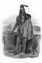
| Date: | 1832 |
|---|---|
| Description: | Abdih-Hiddisch, a Minatarre Chief, posed holding an ax. |
| Date: | 1784 |
|---|---|
| Description: | Plate 39. Portrait from Cook's Third Expedition, 1776-1779, while in Alaska. |
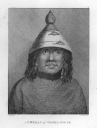
| Date: | 1784 |
|---|---|
| Description: | Plate 46. Portrait from Cook's Third Expedition, 1776-1779, while in Alaska. |

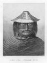
| Date: | 1784 |
|---|---|
| Description: | Plate 50. Portrait from Cook's Third Expedition, 1776-1779, while in Alaska. |
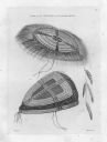
| Date: | 1784 |
|---|---|
| Description: | Plate 56. Drawing from Cook's Third Expedition, 1776-1779, while in Alaska. |
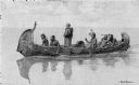
| Date: | 1892 |
|---|---|
| Description: | Photographic print of an engraved image showing a robed missionary standing in a birch bark canoe paddled by four Native Americans and another man who appe... |

| Date: | 1790 |
|---|---|
| Description: | An updated and corrected version of Robert de Vaugondy's 1750 map "Amérique Septentrionale: Dressée sur les Relations les Plus Modernes des Voyageurs et Na... |

| Date: | 1676 |
|---|---|
| Description: | Detailed map of North and South America. Cities, towns, forests, and mountains are shown pictorially. Duval labels regions, islands, cities, lakes, and Nat... |

| Date: | 1780 |
|---|---|
| Description: | Map of North and South America, showing the boundaries of colonial territories, cities, settlements, rivers, lakes, and Native American land. Particular em... |

| Date: | 1684 |
|---|---|
| Description: | Map of North America showing some colonies, cities, rivers, lakes, and Native American land. Ship routes spread across both oceans, including one decorated... |

| Date: | 1683 |
|---|---|
| Description: | Map of the north east coast of North America showing islands, regions, Native American land, bays, and a few European settlements. The Great Lakes appear i... |

| Date: | 1710 |
|---|---|
| Description: | Map of North America showing the European claims, Native American land and villages, rivers, lakes, cities, and notes on explorers, discoveries, and topogr... |

| Date: | 1719 |
|---|---|
| Description: | Map of North America showing land divisions between France, Spain, England, Sweden, Denmark and Holland. The map is detailed, labeling cities, forts, islan... |

| Date: | 1770 |
|---|---|
| Description: | Map of North America from the Great Lakes to the northern portion of South America. It shows cities, Native American land, mountains, swamps, lakes, rivers... |

| Date: | 1759 |
|---|---|
| Description: | Map of north eastern Canada and parts of New England, showing settlements, cities, portages, Native American land, mountains, lakes, and rivers. The unusua... |

| Date: | 1784 |
|---|---|
| Description: | Detailed and ornate map of the newly formed United States. The borders of the southern states extend to the Mississippi River, though the states are only c... |

| Date: | 1667 |
|---|---|
| Description: | Map of Virginia depicting the discoveries detailed by John Smith in his exploration of the region. It shows Jamestown, Native American tribes and villages,... |

| Date: | |
|---|---|
| Description: | Painted portrait of a man in a feathered headdress with buffalo horns. He is wearing a cloak with an animal face in front, and he is holding a war club and... |
If you didn't find the material you searched for, our Library Reference Staff can help.
Call our reference desk at 608-264-6535 or email us at: