 Filter: Categories of Wisconsin Historical Images
Filter: Subject of Great Lakes
Filter: Subject of intellectual life
Filter: Categories of Wisconsin Historical Images
Filter: Subject of Great Lakes
Filter: Subject of intellectual life

| Date: | 05 01 2014 |
|---|---|
| Description: | Underwater view of the bow of the Rouse Simmons with a Christmas tree placed on it. Local divers, every year (typically on the date the Rouse Sim... |

| Date: | 08 14 2014 |
|---|---|
| Description: | Underwater view of one of the deadeyes, in the middle of the ship along the port side, used on the scow schooner Success. The ship and rigging are p... |
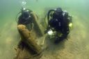
| Date: | 08 15 2014 |
|---|---|
| Description: | Underwater view of two archaeologists measuring and surveying the site of the Success. Much of the ship remains buried under sand. |

| Date: | 09 26 2014 |
|---|---|
| Description: | Underwater view of an archaeologist surveying the bilge pump of the Success. The pump is resting in a bed of sand towards the stern of the ship. Tex... |

| Date: | 08 15 2014 |
|---|---|
| Description: | Underwater view of the capstan of the Success. The capstan is laying on its side embedded in the sand, near the stern on the starboard side of the s... |

| Date: | 08 15 2014 |
|---|---|
| Description: | Underwater view of the capstan on the scow schooner Success. It is laying on its side partially buried in sand. A section of the starboard side of t... |

| Date: | 1937 |
|---|---|
| Description: | This map shows the major roads, cities, towns, lakes, and rivers of Wisconsin and some of the neighboring states. The front includes an add for Coca-Cola, ... |

| Date: | 1937 |
|---|---|
| Description: | This map shows the major cities, towns, highways, roads, lakes, and rivers of Wisconsin and some of the neighboring states. An index is included on the fro... |

| Date: | 08 2007 |
|---|---|
| Description: | Underwater view of the Apomattox's floor keelsons near the bow. |
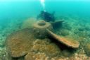
| Date: | 2006 |
|---|---|
| Description: | Underwater view of a propeller located off of the Appomattox wreck site, near Shorewood, in Lake Michigan. The diver is Kimm Stabelfeldt. |

| Date: | 1881 |
|---|---|
| Description: | This map shows railroads, county boundaries, cities, towns, and waterways with relief shown by hachures. The prime meridians are: Greenwich and Washington.... |

| Date: | 1887 |
|---|---|
| Description: | This map shows railroads, county boundaries, cities, towns, and waterways with relief shown by hachures. The prime meridians are: Greenwich and Washington.... |

| Date: | 1710 |
|---|---|
| Description: | A seminal and fairly accurate map of the Great Lakes Region up to Baffin's Bay in Northern Canada. This is possibly the first printed map to locate Detroit... |

| Date: | 1696 |
|---|---|
| Description: | This sea chart and topographical map depicts the north east coast of Canada and North America, focusing on the Hudson Bay and Great Lakes regions. It shows... |

| Date: | 1685 |
|---|---|
| Description: | A detailed map of the western hemisphere showing cities, settlements, Native American land, rivers, lakes, mountains, the Great Lakes, and California as an... |

| Date: | 1766 |
|---|---|
| Description: | Map of the north western hemisphere using sinusoidal projection to show the curvature of the earth. It labels regions, cities, Native American land, island... |

| Date: | 1755 |
|---|---|
| Description: | Map of colonial America, showing the lands north of South Carolina and west of the Mississippi River. An inset map of the Carolinas and Georgia sits in the... |

| Date: | 1720 |
|---|---|
| Description: | Detailed, ornate, and comprehensive map of America from the east coast to present day Texas. Numerous features appear throughout the map, including Native ... |

| Date: | |
|---|---|
| Description: | Drawing of a map showing the cruise routes from Eagle Inn Dock and the points of interest. There is a schedule and rates on the reverse. |

| Date: | |
|---|---|
| Description: | Aerial view of Ephraim and Eagle Bay. A two-lane highway runs along the coastline. Caption reads: "Ephraim, Wisconsin." |
If you didn't find the material you searched for, our Library Reference Staff can help.
Call our reference desk at 608-264-6535 or email us at: