 Filter: Categories of Wisconsin Historical Images
Filter: Subject of Fortification
Filter: Subject of military camps
Filter: Categories of Wisconsin Historical Images
Filter: Subject of Fortification
Filter: Subject of military camps
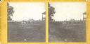
| Date: | 1853 |
|---|---|
| Description: | Stereograph of the interior of Fort Howard after its decommissioning in 1853. |

| Date: | 1816 |
|---|---|
| Description: | This is a photostat copy of a manuscript map in the National Archives showing a plan of Fort Howard and a view of its north side. Originally surveyed by Wi... |

| Date: | 08 22 1943 |
|---|---|
| Description: | Corporal Eugene Cierzynski of Milwaukee, Wisconsin (left) instructs Corporal Edgar Hourscht of Trosky, Minnesota (right), on how to operate a D-8 Caterpill... |

| Date: | 1900 |
|---|---|
| Description: | This map shows portion of the military road from Fond du Lac to the Wisconsin River near Fort Winnebago, with mile markers and adjacent land use. A few pro... |

| Date: | 10 1776 |
|---|---|
| Description: | Broadside map showing the British invasion of New York city in August and September of 1776. The map shows important cities, forts, roads, hills, mountains... |

| Date: | 02 1777 |
|---|---|
| Description: | Map depicting the campaigns of October and November 1776, in Manhattan, Westchester, and part of New Jersey, published only a few months after the conclusi... |

| Date: | 03 1777 |
|---|---|
| Description: | Map showing the British and Hessian attack on Fort Washington in November of 1776. The movements and fortifications of the British and Hessian troops appea... |

| Date: | 04 1777 |
|---|---|
| Description: | Map showing the area from Newtown, Pennsylvania to Kingston, New Jersey, with routes and battles of British (red) and American forces (blue). The map inclu... |
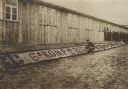
| Date: | 1914 |
|---|---|
| Description: | French PoW's beautifying the exterior of a barracks building in the camp at Zossen. |
If you didn't find the material you searched for, our Library Reference Staff can help.
Call our reference desk at 608-264-6535 or email us at: