 Filter: Categories of Wisconsin Historical Images
Filter: Subject of Ferries
Filter: Year of 1900-1999
Filter: Year of 1950-1959
Filter: Categories of Wisconsin Historical Images
Filter: Subject of Ferries
Filter: Year of 1900-1999
Filter: Year of 1950-1959

| Date: | 1951 |
|---|---|
| Description: | View from road of the Merrimac ferry approaching shore with several automobiles and a large truck aboard. In the foreground is a sign that reads: "Keep Bac... |

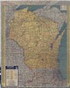
| Date: | 1950 |
|---|---|
| Description: | This road map shows federal, state and county roads in Wisconsin, northern Illinois, northeastern Iowa, eastern Minnesota, and the western portion of Michi... |
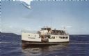
| Date: | 1950 |
|---|---|
| Description: | Color photographic postcard of the "C.G. Richter," a ferry operating between mainland Door County and Washington Island in Wisconsin. |
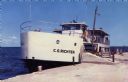
| Date: | 1950 |
|---|---|
| Description: | Color photographic postcard view of the "C.G. Richter" at the dock, a ferry operating between mainland Door County and Washington Island. |
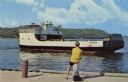
| Date: | 1950 |
|---|---|
| Description: | View from dock towards the Washington Island Ferry, "Eyrarbakki." There is a person sitting on a post on the dock. |

| Date: | 12 17 1957 |
|---|---|
| Description: | Carferry slip with pilings in the foreground, and a shoreline in the background. The pier is made of timbers. In the background on the left is a factory wi... |
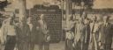
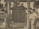
| Date: | 06 05 1955 |
|---|---|
| Description: | Officials gathered to dedicate the Knaggs Ferry historical marker in Oshkosh. The officials included, from left to right, Edward Hamilton, vice-president o... |
| Date: | 06 05 1955 |
|---|---|
| Description: | Fourth, fifth, and sixth generations of the Knaggs family gathered by the Knaggs Ferry historical marker to honor their family member. Mrs. Walter Dugolens... |
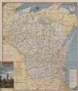
| Date: | 1951 |
|---|---|
| Description: | This colored road map shows automobile roads in Wisconsin as well as portions of nearby states. Information on the quality and type of any road shown (pave... |
| Date: | 1954 |
|---|---|
| Description: | This map is designed to help Catholic tourists in Wisconsin find Catholic churches and missions. On the front side, a road map of Wisconsin showing the loc... |

| Date: | 1955 |
|---|---|
| Description: | This colored road map shows automobile roads in Wisconsin as well as portions of nearby states. Information on the quality and type of any road shown (U.S.... |
| Date: | 1955 |
|---|---|
| Description: | This colored road map shows automobile roads in Wisconsin as well as portions of nearby states. Information on the quality and type of any road shown (pave... |

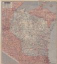
| Date: | 1956 |
|---|---|
| Description: | This colored road map shows automobile roads in Wisconsin as well as portions of nearby states. The map is organized such that a single map of Wisconsin is... |

| Date: | 1957 |
|---|---|
| Description: | This colored road map shows automobile roads in Wisconsin as well as portions of nearby states. The map is organized such that a single map of Wisconsin is... |

| Date: | 1959 |
|---|---|
| Description: | This colored road map shows roads in Wisconsin as well as portions of nearby states. Information on the quality and type of any road shown (expressways, St... |
If you didn't find the material you searched for, our Library Reference Staff can help.
Call our reference desk at 608-264-6535 or email us at: