 Filter: Categories of Wisconsin Historical Images
Filter: Subject of Exploration
Filter: Subject of intellectual life
Filter: Categories of Wisconsin Historical Images
Filter: Subject of Exploration
Filter: Subject of intellectual life

| Date: | 1823 |
|---|---|
| Description: | In 1823 U.S. Army major Stephen H. Long led an expedition of scientific, trade, and military investigation up the Mississippi River and the Red River of th... |

| Date: | 08 17 1965 |
|---|---|
| Description: | NBC News broadcaster Merrill Mueller interviewing Lockheed engineer Bud Zeller about the Gemini Agena Target Vehicle. The interview was part of a public re... |
| Date: | |
|---|---|
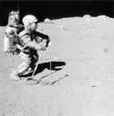
| Description: | Astronaut Charles M Duke, Jr., collecting lunar samples using a rake and tongs. This photograph was taken on the moon by John W. Young, the crew commander.... |
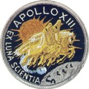
| Date: | 1972 |
|---|---|
| Description: | Mission patch design for Apollo 13. This patch was worn by Commander James A. Lovell, Jr., formerly of Milwaukee; John L. Swigert, Jr.; and Fred W Haise, ... |
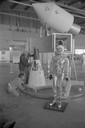
| Date: | 1965 |
|---|---|
| Description: | A traveling display about the NASA manned space program on exhibit at Austin Straubel Airport. Included in the exhibit is a model of a space capsule and a ... |

| Date: | 1893 |
|---|---|
| Description: | Front and back covers of an advertising brochure for the New Empire line of mowers, reapers and grain binders manufactured by J.F. Seiberling & Company. Th... |

| Date: | 08 13 1970 |
|---|---|
| Description: | Cover of "Chinook," an underground newspaper, featuring an ethereal drawing of a male hiker holding out a sign with an infinity symbol on it, as though he ... |
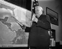
| Date: | 10 24 1962 |
|---|---|
| Description: | Senator Alexander Wiley posing with a model of a missile pointed at a map of Cuba. |

| Date: | 1836 |
|---|---|
| Description: | This map depicts Wisconsin and Michigan territories in 1836. It includes the area from Michigan to the Missouri River and Lake Winnipeg, and it shows the e... |

| Date: | 08 22 1961 |
|---|---|
| Description: | Portrait of Dr. Krafft A. Ehricke, program director of the astronautics division of General Dynamics Corporation. He spoke at the Wisconsin Union Theater t... |

| Date: | 1786 |
|---|---|
| Description: | This map is an updated version of d'Anville's 1761 map of the western hemisphere. He included more details to the north west coast of North America, partic... |

| Date: | 1710 |
|---|---|
| Description: | A seminal and fairly accurate map of the Great Lakes Region up to Baffin's Bay in Northern Canada. This is possibly the first printed map to locate Detroit... |

| Date: | 1715 |
|---|---|
| Description: | One of Herman Moll's most famous maps, often referred to as The Codfish Map, it shows rivers and portages, cities, Indian villages, wind directions, routes... |

| Date: | 1720 |
|---|---|
| Description: | This map of North America shows cities, rivers, lakes, and a few topographical features, complete with numerous descriptive blocks of text about expedition... |

| Date: | 1780 |
|---|---|
| Description: | This map shows the northern Pacific Ocean with North America and Asia, with cities and geographical features labeled, as well Russian, French and Spanish r... |

| Date: | 1755 |
|---|---|
| Description: | This map shows forts, missions, villages and cities, rivers and portages, and boundaries of the Spanish, English, and French territories, marking the large... |

| Date: | 1786 |
|---|---|
| Description: | One half of a four sheet nautical chart, showing the coastlines of the north-west hemisphere. The interior lands are left bare, even of basic features such... |

| Date: | 1775 |
|---|---|
| Description: | This map shows the northern Pacific Ocean along with north eastern Asia and western North America. The interior of Asia contains detailed engravings of pla... |

| Date: | 1790 |
|---|---|
| Description: | An updated and corrected version of Robert de Vaugondy's 1750 map "Amérique Septentrionale: Dressée sur les Relations les Plus Modernes des Voyageurs et Na... |

| Date: | 1696 |
|---|---|
| Description: | This sea chart and topographical map depicts the north east coast of Canada and North America, focusing on the Hudson Bay and Great Lakes regions. It shows... |
If you didn't find the material you searched for, our Library Reference Staff can help.
Call our reference desk at 608-264-6535 or email us at: