Filter: Categories of Wisconsin Historical Images
Filter: Subject of Exploration
Filter: Reproduction Rights of For Sale
Filter: Subject of human settlements
Filter: Categories of Wisconsin Historical Images
Filter: Subject of Exploration
Filter: Reproduction Rights of For Sale
Filter: Subject of human settlements
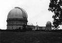
| Date: | 1935 |
|---|---|
| Description: | Elevated exterior view of Yerkes Observatory. Geneva Lake is in the background, left. Roads and sidewalks cross the sweeping, well tended lawns. The desi... |
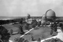
| Date: | 1880 |
|---|---|
| Description: | Elevated view of the University of Wisconsin-Madison Washburn Observatory. Hill, trees and fields are in the background. A man is standing near a small obs... |
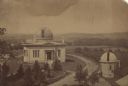
| Date: | 1905 |
|---|---|
| Description: | View across field towards the observatory. Caption reads: "Yerkes Observatory, Lake Geneva, Wis." |

| Date: | 1935 |
|---|---|
| Description: | The entrance to Yerkes Observatory. Caption reads: "Entrance, Yerkes Observatory, University of Chicago, at Williams Bay, Wis." |

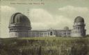
| Date: | 1950 |
|---|---|
| Description: | Bird's-eye view of Yerkes Observatory. |

| Date: | 10 03 1976 |
|---|---|
| Description: | Exterior of Washburn Observatory, a gift to the University of Wisconsin-Madison from Cadwallader C. Washburn, on Observatory Hill overlooking Lake Mendota,... |

| Date: | 1855 |
|---|---|
| Description: | Map reads "Our Country" which is accompanied by a sailor with a flag to the left and workers rejoicing under the Constitution and Laws to the right. Across... |

| Date: | 1836 |
|---|---|
| Description: | This map depicts Wisconsin and Michigan territories in 1836. It includes the area from Michigan to the Missouri River and Lake Winnipeg, and it shows the e... |

| Date: | 1761 |
|---|---|
| Description: | This map shows the western hemisphere. Much of the north-west coast of North America is left blank, but the rest of the map lists the names of rivers, citi... |

| Date: | 1786 |
|---|---|
| Description: | This map is an updated version of d'Anville's 1761 map of the western hemisphere. He included more details to the north west coast of North America, partic... |

| Date: | 1710 |
|---|---|
| Description: | A seminal and fairly accurate map of the Great Lakes Region up to Baffin's Bay in Northern Canada. This is possibly the first printed map to locate Detroit... |

| Date: | 1715 |
|---|---|
| Description: | One of Herman Moll's most famous maps, often referred to as The Codfish Map, it shows rivers and portages, cities, Indian villages, wind directions, routes... |

| Date: | 1720 |
|---|---|
| Description: | This map of North America shows cities, rivers, lakes, and a few topographical features, complete with numerous descriptive blocks of text about expedition... |

| Date: | 1780 |
|---|---|
| Description: | This map shows the northern Pacific Ocean with North America and Asia, with cities and geographical features labeled, as well Russian, French and Spanish r... |

| Date: | 1755 |
|---|---|
| Description: | This map shows forts, missions, villages and cities, rivers and portages, and boundaries of the Spanish, English, and French territories, marking the large... |

| Date: | 1786 |
|---|---|
| Description: | One half of a four sheet nautical chart, showing the coastlines of the north-west hemisphere. The interior lands are left bare, even of basic features such... |

| Date: | 1775 |
|---|---|
| Description: | This map shows the northern Pacific Ocean along with north eastern Asia and western North America. The interior of Asia contains detailed engravings of pla... |
If you didn't find the material you searched for, our Library Reference Staff can help.
Call our reference desk at 608-264-6535 or email us at: