 Filter: Categories of Wisconsin Historical Images
Filter: Subject of Engraving
Filter: Subject of transportation
Filter: Subject of clothing
Filter: Categories of Wisconsin Historical Images
Filter: Subject of Engraving
Filter: Subject of transportation
Filter: Subject of clothing
| Date: | |
|---|---|
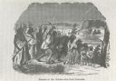
| Description: | Photograph of an engraving from an unknown source depicting a group of Native American warriors herding white captives along a trail. A building burns in ... |
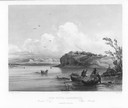
| Date: | 1832 |
|---|---|
| Description: | Mih-Tutta-Hangkusch, a Mandan village with boats on the river in foreground. |
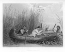
| Date: | 1884 |
|---|---|
| Description: | Three women in a canoe harvest wild rice. |

| Date: | 1784 |
|---|---|
| Description: | Plate 45. Scene from Cook's Third Expedition, 1776-1779, while in Alaska. |

| Date: | |
|---|---|
| Description: | Letterhead of the Kewaskum Mutual Fire Insurance Company of Washington County, Wisconsin, with a Native American man wearing buckskin clothes and leggings ... |
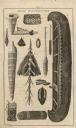
| Date: | 1821 |
|---|---|
| Description: | An illustration of items manufactured by Indians, including a canoe, two paddles, moccasins, rolled mat, pipe bowl, and a beaded bag. |
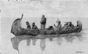
| Date: | 1892 |
|---|---|
| Description: | Photographic print of an engraved image showing a robed missionary standing in a birch bark canoe paddled by four Native Americans and another man who appe... |

| Date: | 1627 |
|---|---|
| Description: | Map of North and South America showing settlements, rivers, lakes, mountains, islands and regions of the western hemisphere. It includes an inset map of Gr... |

| Date: | 1630 |
|---|---|
| Description: | One of the few maps by Dutch cartographer Willem Blaeu depicting the Americas, this map shows regions, settlements, islands, mountains, forests, rivers, an... |

| Date: | 1636 |
|---|---|
| Description: | Map of North America, divided into regions, and showing some rivers, lakes, settlements, cities, mountains, and Native American land. Of the Great Lakes on... |

| Date: | 1770 |
|---|---|
| Description: | Map of North America from the Great Lakes to the northern portion of South America. It shows cities, Native American land, mountains, swamps, lakes, rivers... |

| Date: | 1720 |
|---|---|
| Description: | Detailed, ornate, and comprehensive map of America from the east coast to present day Texas. Numerous features appear throughout the map, including Native ... |
If you didn't find the material you searched for, our Library Reference Staff can help.
Call our reference desk at 608-264-6535 or email us at: