 Filter: Categories of Wisconsin Historical Images
Filter: Subject of Engraving
Filter: Subject of signs and symbols
Filter: Subject of human settlements
Filter: Categories of Wisconsin Historical Images
Filter: Subject of Engraving
Filter: Subject of signs and symbols
Filter: Subject of human settlements

| Date: | 1847 |
|---|---|
| Description: | Engraving of the McCormick Reaper Works as it appeared in 1847. The factory was located on the north bank of the Chicago River, east of the Michigan Avenue... |
| Date: | 1867 |
|---|---|
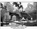
| Description: | Engraving of the McCormick Reaper Works as it appeared in 1867. The factory was located on the north bank of the Chicago River, east of the Rush Street bri... |
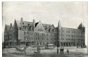
| Date: | 1860 |
|---|---|
| Description: | Elevated view of the Durkee House built by Charles Durkee in 1843. |
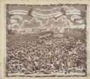
| Date: | |
|---|---|
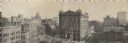
| Description: | Panoramic view from the top of a building. Home of Merchants and Manufacturers' Association of Milwaukee. Building is in the center of the image, with two ... |
| Date: | 1878 |
|---|---|
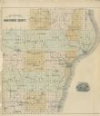
| Description: | Outline map of Manitowoc County. Includes engraving of Wisconsin State Seal at bottom right. |
| Date: | 02 1932 |
|---|---|
| Description: | Engraving by Charles Silver to mark the passage of Wisconsin's Unemployment Compensation Law, the first in the nation. |
| Date: | 1891 |
|---|---|
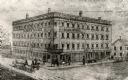
| Description: | Exterior view of the West Superior Hotel. There are pedestrians, a street car, and people riding in horse-drawn carriages on the street in front of the hot... |
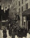
| Date: | 1819 |
|---|---|
| Description: | A commemorative handkerchief created by a wood engraving on white cotton fabric. The scene is the Manchester Reform Meeting, in England. A crowd of demonst... |
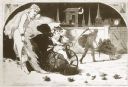
| Date: | 01 1869 |
|---|---|
| Description: | Engraving after a drawing by Winslow Homer showing a crowned Baby New Year riding a velocipede through a hoop held by a woman, as the Grim Reaper, on the r... |

| Date: | 1712 |
|---|---|
| Description: | Engraved double-hemispherical world map by Moll, included in his atlas The world described, or, A new and correct sett of maps: shewing the kingdoms and st... |

| Date: | 1667 |
|---|---|
| Description: | Map of Virginia depicting the discoveries detailed by John Smith in his exploration of the region. It shows Jamestown, Native American tribes and villages,... |

| Date: | 1671 |
|---|---|
| Description: | Map of Virginia depicting the discoveries detailed by John Smith in his exploration of the region. It shows Jamestown, Native American tribes and villages,... |
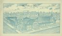
| Date: | 1902 |
|---|---|
| Description: | Text on front reads: "West Bend, Wis.,_______190___" with space for the date. An engraving of the Enger-Kress Pocket Book Company printed in blue ink. Orig... |
If you didn't find the material you searched for, our Library Reference Staff can help.
Call our reference desk at 608-264-6535 or email us at: