 Filter: Categories of Wisconsin Historical Images
Filter: Subject of Engraving
Filter: Subject of ships
Filter: Subject of intellectual life
Filter: Categories of Wisconsin Historical Images
Filter: Subject of Engraving
Filter: Subject of ships
Filter: Subject of intellectual life

| Date: | 1655 |
|---|---|
| Description: | Christopher Columbus begins his first expedition, 1492. |
| Date: | 1885 |
|---|---|
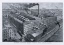
| Description: | Engraved bird's-eye view illustration of the "McCormick Harvesting Machine Company's Works," including railroad cars, smoke from smokestacks and factory wo... |
| Date: | |
|---|---|
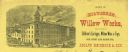
| Description: | Letterhead of the Milwaukee Willow Works, a manufacturer of children's carriages, willow ware, and toys, with a three-quarter view of the company building,... |

| Date: | |
|---|---|
| Description: | Memohead of the Milwaukee Dry Dock Company, which operated two docks, with a view of a dock with ships, planks of wood, buildings, and the slogan, "Electri... |
| Date: | 11 26 1898 |
|---|---|
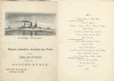
| Description: | Menu for a "Banquet tendered by the Union Iron Works to the Delegation from the Badger State" given at the Palace Hotel, with an etching of the Battleship ... |

| Date: | |
|---|---|
| Description: | Letterhead of Johnson & Melaas, merchant tailors and cloth dealers, "Buyers of wool and Wisconsin leaf tobacco," with an engraving of a waterfront view of ... |

| Date: | 1750 |
|---|---|
| Description: | Map of the northeast corner of America and Canada with hand-colored boundaries. The map shows colonies, Native American nations, fishing areas, and detaile... |

| Date: | 1556 |
|---|---|
| Description: | One of the earliest obtainable maps to accurately (for its time) depict the Americas, this map shows more decorative than descriptive features. A few river... |

| Date: | 1627 |
|---|---|
| Description: | Map of North and South America showing settlements, rivers, lakes, mountains, islands and regions of the western hemisphere. It includes an inset map of Gr... |

| Date: | 1630 |
|---|---|
| Description: | One of the few maps by Dutch cartographer Willem Blaeu depicting the Americas, this map shows regions, settlements, islands, mountains, forests, rivers, an... |

| Date: | 1679 |
|---|---|
| Description: | Decorative and detailed map of the eastern half of North America. Regions, cities, colonies, Native America land, rivers, lakes and some nautical features ... |

| Date: | 1700 |
|---|---|
| Description: | Map of the western hemisphere showing settelments, coastal features, islands, rivers, lakes, and pictoral representations of forests and mountains. The Gre... |

| Date: | 1636 |
|---|---|
| Description: | Map of North America, divided into regions, and showing some rivers, lakes, settlements, cities, mountains, and Native American land. Of the Great Lakes on... |

| Date: | 1684 |
|---|---|
| Description: | Map of North America showing some colonies, cities, rivers, lakes, and Native American land. Ship routes spread across both oceans, including one decorated... |

| Date: | 1713 |
|---|---|
| Description: | Map showing the regions explored by Robert de La Salle between 1681 and 1686, as well as the route La Salle, and later Henri Joutel, took, moving north fro... |

| Date: | 1733 |
|---|---|
| Description: | This map of North America shows settlements, rivers, lakes, Native American land, trade winds, and numerous topographical features such as forests and moun... |

| Date: | 1775 |
|---|---|
| Description: | This six sheet large format map is one of the most informative maps of its time. It shows cities, Native American land, lakes, rivers, mountains, topograph... |

| Date: | 1758 |
|---|---|
| Description: | Map showing lakes, rivers, cities, Native American land, and the boundaries of French and English claims in America and Canada north of New York. A title c... |

| Date: | 1770 |
|---|---|
| Description: | Map of North America from the Great Lakes to the northern portion of South America. It shows cities, Native American land, mountains, swamps, lakes, rivers... |

| Date: | 1759 |
|---|---|
| Description: | Map of north eastern Canada and parts of New England, showing settlements, cities, portages, Native American land, mountains, lakes, and rivers. The unusua... |
If you didn't find the material you searched for, our Library Reference Staff can help.
Call our reference desk at 608-264-6535 or email us at: