 Filter: Categories of Wisconsin Historical Images
Filter: Subject of Engraving
Filter: Subject of science
Filter: Subject of trees
Filter: Categories of Wisconsin Historical Images
Filter: Subject of Engraving
Filter: Subject of science
Filter: Subject of trees
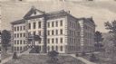
| Date: | 1876 |
|---|---|
| Description: | Engraving of the first Science Hall at University of Wisconsin-Madison. |

| Date: | 1923 |
|---|---|
| Description: | Drawing of a tree with a banner over it reading Eugenics. The roots of the tree are labeled with sciences and fields connected to eugenics. Text on ... |

| Date: | 1715 |
|---|---|
| Description: | One of Herman Moll's most famous maps, often referred to as The Codfish Map, it shows rivers and portages, cities, Indian villages, wind directions, routes... |

| Date: | 1783 |
|---|---|
| Description: | This map is hand-colored and shows the boundaries of British, Spanish, and the newly recognized American claims, as well as the fishing rights granted to F... |

| Date: | 1746 |
|---|---|
| Description: | Detailed map of the western hemisphere and part of Africa and Europe. Islands, cities, settlements, rivers, lakes, countries, and regions are marked. Mount... |

| Date: | 1770 |
|---|---|
| Description: | Map of North America showing the boundaries between French, Spanish, and English claims after the French and Indian War. Kitchin includes numerous place na... |

| Date: | 1759 |
|---|---|
| Description: | Map of north eastern Canada and parts of New England, showing settlements, cities, portages, Native American land, mountains, lakes, and rivers. The unusua... |

| Date: | 1720 |
|---|---|
| Description: | Detailed, ornate, and comprehensive map of America from the east coast to present day Texas. Numerous features appear throughout the map, including Native ... |
If you didn't find the material you searched for, our Library Reference Staff can help.
Call our reference desk at 608-264-6535 or email us at: