Filter: Categories of Wisconsin Historical Images
Filter: Subject of Engraving
Filter: Subject of roads
Filter: Categories of Wisconsin Historical Images
Filter: Subject of Engraving
Filter: Subject of roads

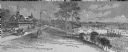
| Date: | 1857 |
|---|---|
| Description: | Bird's-eye view of Madison over rooftop and across lake with sailboats and steamers. A group of people are standing on a viewing platform on the roof in th... |

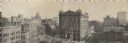
| Date: | 1937 |
|---|---|
| Description: | Bird's-eye view of Milwaukee in 1853 details building features and city layout from southwest. Important buildings are numbered in a silhouette drawing bel... |
| Date: | |
|---|---|
| Description: | An engraving based on a drawing by Alexander Simplot of the Platteville Brewery (spelled Plattville). It is an elevated perspective showing the main buildi... |

| Date: | 1862 |
|---|---|
| Description: | Birds-eye view of a Wisconsin Civil War regiment on parade in Fond du Lac, as drawn by Louis Kurz from the Marr Street Methodist Church. The regiment canno... |
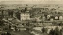
| Date: | |
|---|---|
| Description: | Panoramic view from the top of a building. Home of Merchants and Manufacturers' Association of Milwaukee. Building is in the center of the image, with two ... |

| Date: | 1870 |
|---|---|
| Description: | Magazine illustration of the home, titled: "Soldiers' National Asylum at Milwaukee, Wisconsin". The building is in the background, and in the foreground ar... |
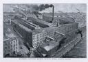
| Date: | 1885 |
|---|---|
| Description: | Engraved bird's-eye view illustration of the "McCormick Harvesting Machine Company's Works," including railroad cars, smoke from smokestacks and factory wo... |

| Date: | |
|---|---|
| Description: | Engraving of Wisconsin Institute for Deaf and Dumb. A man in a horse-drawn carriage and another rider on horseback travel along the street in the foregroun... |
| Date: | |
|---|---|
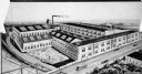
| Description: | Drawing showing the entire exterior of Pearl Button Company. |

| Date: | |
|---|---|
| Description: | Letterhead of the Kewaskum Mutual Fire Insurance Company of Washington County, Wisconsin, with a Native American man wearing buckskin clothes and leggings ... |
| Date: | 02 1855 |
|---|---|
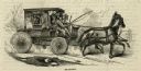
| Description: | Engraved image from Harper's New Monthly Magazine showing people riding in a stagecoach pulled by two horses. |
| Date: | 12 20 1879 |
|---|---|
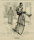
| Description: | Engraved image of a man coasting on a high-wheel bicycle. He has his legs draped over the handlebars, and his hands on the handlebars, leaving the pedals f... |
| Date: | 03 06 1869 |
|---|---|
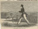
| Description: | Engraved image of a man in a top hat and tails riding a velocipede. Another rider is in the background. |

| Date: | |
|---|---|
| Description: | Engraved print of a man riding atop a wagonload of hay pulled by a horse along a road in a hilly rural area. On the left is a barn and silos. |
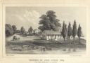
| Date: | 1856 |
|---|---|
| Description: | Lithograhic view of the residence of John Kinzie on the bank of the Chicago River at the mouth of Lake Michigan. The residence consists of a house with a f... |

| Date: | 1776 |
|---|---|
| Description: | This was one of the first maps available for the general British populace featuring America during the Revolutionary War. It includes forts, cities, topogr... |

| Date: | 1777 |
|---|---|
| Description: | This detailed map of the American colonies shows cities, villages, roads, mountains, lakes, rivers, swamps, counties, state boundaries, and Native American... |

| Date: | 1780 |
|---|---|
| Description: | This map shows the townships, parishes, cities, towns, plantations, lakes, rivers, swamps, and roads near the coast of South Carolina and Georgia. Emphasis... |

| Date: | 1776 |
|---|---|
| Description: | Map of the American colonies and land east of the Mississippi River. Prominent cities, forts, Native American land, mountains, rivers and lakes are all sho... |
If you didn't find the material you searched for, our Library Reference Staff can help.
Call our reference desk at 608-264-6535 or email us at: