 Filter: Categories of Wisconsin Historical Images
Filter: Subject of Engraving
Filter: Subject of intellectual life
Filter: Subject of rivers
Filter: Categories of Wisconsin Historical Images
Filter: Subject of Engraving
Filter: Subject of intellectual life
Filter: Subject of rivers

| Date: | 1821 |
|---|---|
| Description: | Engraving depicting the Schoolcraft expedition crossing the Ontonagon River to investigate a copper boulder. |

| Date: | 1937 |
|---|---|
| Description: | Bird's-eye view of Milwaukee in 1853 details building features and city layout from southwest. Important buildings are numbered in a silhouette drawing bel... |

| Date: | 1820 |
|---|---|
| Description: | Map of the Northwestern Territories of the United State showing the track pursued by the Expedition in 1820. |
| Date: | |
|---|---|
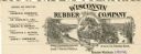
| Description: | Letterhead of the Wisconsin Rubber Company of Madison, Wisconsin, which operated the Florida plantation in the state of Chiapas, Mexico. Includes an oval i... |
| Date: | |
|---|---|
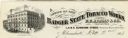
| Description: | Letterhead of the Badger State Tobacco Works of Milwaukee, Wisconsin, with a three-quarter view of the building, men working on boats moored near the water... |
| Date: | |
|---|---|
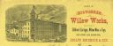
| Description: | Letterhead of the Milwaukee Willow Works, a manufacturer of children's carriages, willow ware, and toys, with a three-quarter view of the company building,... |

| Date: | |
|---|---|
| Description: | Memohead of the Milwaukee Dry Dock Company, which operated two docks, with a view of a dock with ships, planks of wood, buildings, and the slogan, "Electri... |

| Date: | 1798 |
|---|---|
| Description: | Engraved and hand-colored map of Egypt. Map title appears on bottom left as a carving in stone next ... |

| Date: | 1721 |
|---|---|
| Description: | A map of North and South America with an elaborately illustrated cartouche depicting Native Americans in upper left corner. The map is fairly detailed, dep... |

| Date: | 1710 |
|---|---|
| Description: | A seminal and fairly accurate map of the Great Lakes Region up to Baffin's Bay in Northern Canada. This is possibly the first printed map to locate Detroit... |

| Date: | 1703 |
|---|---|
| Description: | Map of the Golf of Mexico and surrounding countries from the Great Lakes down to the northern most parts of South America. L'Isle labels cities, towns, and... |

| Date: | 1720 |
|---|---|
| Description: | One of Herman Moll's most famous maps, often referred to as The Beaver Map for its elaborate engraved inset depicting and describing beavers building a dam... |

| Date: | 1719 |
|---|---|
| Description: | Map of the British colonies and territories in North American, depicting cities, Native American land, rivers, mines, forts, trees, and topography east of ... |

| Date: | 1720 |
|---|---|
| Description: | This map of North America shows cities, rivers, lakes, and a few topographical features, complete with numerous descriptive blocks of text about expedition... |

| Date: | 1746 |
|---|---|
| Description: | Map of North America from the southern portion of James Bay to Florida. It shows the colonies, cities, Native American land, and topological and geographic... |

| Date: | 1780 |
|---|---|
| Description: | This map shows the northern Pacific Ocean with North America and Asia, with cities and geographical features labeled, as well Russian, French and Spanish r... |

| Date: | 1758 |
|---|---|
| Description: | This map of the north-west hemisphere shows the cities, lakes, rivers, mountains, and political borders. In the upper left corner sits a decorative cartouc... |

| Date: | 1755 |
|---|---|
| Description: | This map shows forts, missions, villages and cities, rivers and portages, and boundaries of the Spanish, English, and French territories, marking the large... |

| Date: | 1757 |
|---|---|
| Description: | This map shows the cities, plantations, lakes, rivers, mountains, Native American territories and colonial borders of the Eastern half of North America, pl... |

| Date: | 1755 |
|---|---|
| Description: | This map shows the eastern half of North America during the French and Indian war, including cities, borders, Native American Land, forts, and detailed geo... |
If you didn't find the material you searched for, our Library Reference Staff can help.
Call our reference desk at 608-264-6535 or email us at: