 Filter: Categories of Wisconsin Historical Images
Filter: Subject of Engraving
Filter: Subject of agriculture
Filter: Subject of land use
Filter: Categories of Wisconsin Historical Images
Filter: Subject of Engraving
Filter: Subject of agriculture
Filter: Subject of land use
| Date: | |
|---|---|
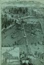
| Description: | An engraving based on a drawing by Alexander Simplot. The image shows a very detailed aerial view of a hillside with a tramway traversing the side. There a... |
| Date: | |
|---|---|
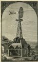
| Description: | Engraving of a farm with an Eclipse windmill. There is a cutaway view of the building beneath showing a man inside working at a saw. Another man is working... |
| Date: | |
|---|---|
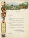
| Description: | Letterhead of the Acme White Lead & Color Works of Detroit, Michigan, which as part of its business produced insecticides for farm and home garden applicat... |
| Date: | |
|---|---|
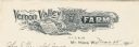
| Description: | Letterhead of Vernon Valley Farm, a breeder of Percheron and coach horses, shorthorn cattle, Berkshire hogs, Bronze turkeys, and Wyandotte chickens from Mt... |
| Date: | |
|---|---|
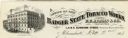
| Description: | Letterhead of the Badger State Tobacco Works of Milwaukee, Wisconsin, with a three-quarter view of the building, men working on boats moored near the water... |
| Date: | |
|---|---|
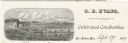
| Description: | Letterhead of G.E. Evans, a grower of cultivated cranberries from New Lisbon, Wisconsin. Includes an illustration by (A.?) R.R. Richards of people working ... |
| Date: | |
|---|---|
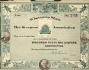
| Description: | Wisconsin State Bee Keepers Association membership certificate, signed by N.E. France Association President. No. 148. Illustrations of clover flowers and b... |
| Date: | 1880 |
|---|---|
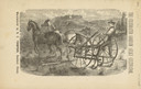
| Description: | Front page of booklet with an engraving of a man with a team of two horses in a field with the "Celebrated Gorham Sulky Cultivator." |

| Date: | 1770 |
|---|---|
| Description: | The south west sheet of a four sheet map of Virginia, showing the counties, mountains, rivers, court houses, a few cities, and mills. A few Plantations ar... |

| Date: | 03 1777 |
|---|---|
| Description: | Map showing the British and Hessian attack on Fort Washington in November of 1776. The movements and fortifications of the British and Hessian troops appea... |

| Date: | 1776 |
|---|---|
| Description: | Fairly detailed map of New York City and parts of Long Island. It shows streets, roads, wharves, ferries, ship yards, Fort George and the battery, public b... |

| Date: | 1755 |
|---|---|
| Description: | Map of Virginia and parts of Maryland, North Carolina, and New Jersey. It shows borders, boundary lines, some Native American land, counties, cities, towns... |

| Date: | 1762 |
|---|---|
| Description: | Map of Virginia and parts of Maryland. It shows borders, boundary lines, Native American tribes and land, towns, forts, roads, mountains, waterfalls, bays,... |

| Date: | 1760 |
|---|---|
| Description: | Map showing the towns, mountains, valleys, corn fields, and rivers of a portion of the Cherokee Nation. A few annotations on the map explain the land and r... |
If you didn't find the material you searched for, our Library Reference Staff can help.
Call our reference desk at 608-264-6535 or email us at: