Filter: Categories of Wisconsin Historical Images
Filter: Subject of Engraving
Filter: Reproduction Rights of For Sale
Filter: Subject of slavery
Filter: Categories of Wisconsin Historical Images
Filter: Subject of Engraving
Filter: Reproduction Rights of For Sale
Filter: Subject of slavery
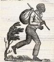
| Date: | 1837 |
|---|---|
| Description: | Image of a runaway slave with stick and satchel. |

| Date: | 1783 |
|---|---|
| Description: | This map is hand-colored and shows the boundaries of British, Spanish, and the newly recognized American claims, as well as the fishing rights granted to F... |

| Date: | 1770 |
|---|---|
| Description: | The south west sheet of a four sheet map of Virginia, showing the counties, mountains, rivers, court houses, a few cities, and mills. A few Plantations ar... |

| Date: | 1780 |
|---|---|
| Description: | This map shows the townships, parishes, cities, towns, plantations, lakes, rivers, swamps, and roads near the coast of South Carolina and Georgia. Emphasis... |

| Date: | 1755 |
|---|---|
| Description: | Map of Virginia and parts of Maryland, North Carolina, and New Jersey. It shows borders, boundary lines, some Native American land, counties, cities, towns... |
If you didn't find the material you searched for, our Library Reference Staff can help.
Call our reference desk at 608-264-6535 or email us at: