Visit our other Wisconsin Historical Society websites!
 Filter: Categories of Wisconsin Historical Images
Filter: Subject of Clothing and dress
Filter: Subject of maps
Filter: Categories of Wisconsin Historical Images
Filter: Subject of Clothing and dress
Filter: Subject of maps

| Date: | 1719 |
|---|---|
| Description: | Map of North America showing land divisions between France, Spain, England, Sweden, Denmark and Holland. The map is detailed, labeling cities, forts, islan... |

| Date: | 1770 |
|---|---|
| Description: | Map of North America from the Great Lakes to the northern portion of South America. It shows cities, Native American land, mountains, swamps, lakes, rivers... |

| Date: | 1740 |
|---|---|
| Description: | Map including the regions and cities of the northern half of North America. Native American land, rivers, lakes, mountains are labeled. Mountains, marshes,... |

| Date: | 1784 |
|---|---|
| Description: | Detailed and ornate map of the newly formed United States. The borders of the southern states extend to the Mississippi River, though the states are only c... |

| Date: | 1720 |
|---|---|
| Description: | Detailed, ornate, and comprehensive map of America from the east coast to present day Texas. Numerous features appear throughout the map, including Native ... |

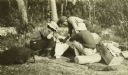
| Date: | 1910 |
|---|---|
| Description: | Fred Carr and Bill Marr reading a map together while sitting on the ground. |
| Date: | 1910 |
|---|---|
| Description: | The Gang is sitting on their packs or bedrolls as they consult their maps with a ranger. |
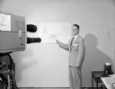
| Date: | 05 28 1953 |
|---|---|
| Description: | WMTV weatherman Paul Ekern is standing and pointing to a weather map in front of a WMTV television camera. |
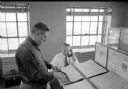
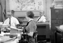
| Date: | 12 22 1953 |
|---|---|
| Description: | Chief of weather operations, L.A. Joos, is on the telephone, while W.C. Williamson is standing at a slanted desk checking one of several weather maps. They... |

| Date: | 1941 |
|---|---|
| Description: | World War II poster published by the National Education Association, showing a teacher working at a globe with a girl and a boy. The boy is holding a book ... |
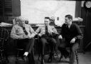
| Date: | 01 20 1954 |
|---|---|
| Description: | Chatting about previous fire fighting experiences are (from left to right): Captain Arthur Wilcox, Firemen Russell Mani, and Wilbur Wright. They are sittin... |

| Date: | 1954 |
|---|---|
| Description: | State Historical Society of Wisconsin staff enjoying a fun moment and posing with a map of Wisconsin and a gnome statue. Left to right: John Jacques, Cliff... |
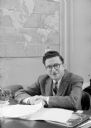
| Date: | 03 25 1955 |
|---|---|
| Description: | Morris Rubin, editor of The Progressive, sitting at his desk decked with a glass ashtray with cigarette, matchbook, and papers. In 1940, Rubin (b.19... |

| Date: | 1865 |
|---|---|
| Description: | Portrait of Reverend Edward Mathews standing in front of a "Moral Map of the United States." He is holding a long, wooden pointer and is gesturing towards ... |
| Date: | 01 06 1958 |
|---|---|
| Description: | Lawrence Fitzpatrick, Managing Editor of the Wisconsin State Journal, sitting at his new desk speaking with someone. A woman and two men are at desk... |

| Date: | 01 16 1959 |
|---|---|
| Description: | Several people looking at a topographical model of Bascom Woods and Muir Knoll by the surrounding buildings between Elizabeth Waters Hall, the Carillon Tow... |

| Date: | 02 07 1958 |
|---|---|
| Description: | Fred Hatch (32), U.S. Weather Bureau technician, will be returning to a small island near the North Pole to conduct experiments on solar energy, insulation... |

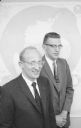
| Date: | 04 04 1958 |
|---|---|
| Description: | Association president, Howard Hershleder, and campaign chairman, H. Kelley Meyer, look over a chart in preparation for the annual fund drive of the Dane Co... |
| Date: | 06 12 1958 |
|---|---|
| Description: | Antarctic explorers Dr. Edward Thiel (left) and John Behrendt (right) recently returned from a year long stay in Antarctica. Dr. Thiel was the co-leader of... |

| Date: | 06 18 1958 |
|---|---|
| Description: | Discussing plans for the Women's division of the United Givers' Fund are, left to right: Constance Helmquist, Elizabeth Schlotthauer, and Helen Quisling. |
If you didn't find the material you searched for, our Library Reference Staff can help.
Call our reference desk at 608-264-6535 or email us at: