 Filter: Categories of Wisconsin Historical Images
Filter: Subject of Clothing and dress
Filter: Subject of intellectual life
Filter: Subject of islands
Filter: Categories of Wisconsin Historical Images
Filter: Subject of Clothing and dress
Filter: Subject of intellectual life
Filter: Subject of islands
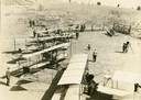
| Date: | 1912 |
|---|---|
| Description: | Photo opportunity day at the Glenn Curtiss School of Aviation on North Island in San Diego Harbor. The man in the lower left corner is thought to be Glenn ... |
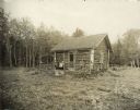
| Date: | 1914 |
|---|---|
| Description: | Log cabin known as the "haunted house" on Rock Island, remodeled by Chester Thordarson. There are three people sitting on the porch. |

| Date: | 1720 |
|---|---|
| Description: | Double hemispherical world map showing routes of Tasman, Magellan, Mendana, etc. Relief shown pictorially. Title in oak wreath cartouche. Map between four ... |

| Date: | 06 12 1960 |
|---|---|
| Description: | A Hawaiian garden is featured in the Maple Bluff Garden Club's flower show. Dorothy Gerhardt and Janet Roth are shown in the exhibit's "little grass shack.... |

| Date: | 03 24 1950 |
|---|---|
| Description: | Front cover of a farewell dinner menu from the Italian Line ship Saturnia, with two Commedia dell' Arte characters: Tartaglia, a rotund figure who w... |

| Date: | 1627 |
|---|---|
| Description: | Map of North and South America showing settlements, rivers, lakes, mountains, islands and regions of the western hemisphere. It includes an inset map of Gr... |

| Date: | 1630 |
|---|---|
| Description: | One of the few maps by Dutch cartographer Willem Blaeu depicting the Americas, this map shows regions, settlements, islands, mountains, forests, rivers, an... |

| Date: | 1676 |
|---|---|
| Description: | Detailed map of North and South America. Cities, towns, forests, and mountains are shown pictorially. Duval labels regions, islands, cities, lakes, and Nat... |

| Date: | 1746 |
|---|---|
| Description: | Detailed map of the western hemisphere and part of Africa and Europe. Islands, cities, settlements, rivers, lakes, countries, and regions are marked. Mount... |

| Date: | 1780 |
|---|---|
| Description: | Map of North and South America, showing the boundaries of colonial territories, cities, settlements, rivers, lakes, and Native American land. Particular em... |

| Date: | 1684 |
|---|---|
| Description: | Map of North America showing some colonies, cities, rivers, lakes, and Native American land. Ship routes spread across both oceans, including one decorated... |

| Date: | 1683 |
|---|---|
| Description: | Map of the north east coast of North America showing islands, regions, Native American land, bays, and a few European settlements. The Great Lakes appear i... |

| Date: | 1719 |
|---|---|
| Description: | Map of North America showing land divisions between France, Spain, England, Sweden, Denmark and Holland. The map is detailed, labeling cities, forts, islan... |

| Date: | 1770 |
|---|---|
| Description: | Map of North America from the Great Lakes to the northern portion of South America. It shows cities, Native American land, mountains, swamps, lakes, rivers... |
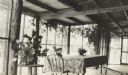
| Date: | 1911 |
|---|---|
| Description: | Seen in profile, Jeannette Holt is sitting in a rocking chair and reading a book, on the new porch addition to Island Lodge. A table with tablecloth and ch... |

| Date: | 1912 |
|---|---|
| Description: | Ellen Holt is reading a book while sitting in a rocking chair on the porch. She is wearing a jacket and skirt. Caption reads: "Ellen Holt." |

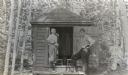
| Date: | 1912 |
|---|---|
| Description: | William Pettigrew, who was Foreman at Camp Four beginning in 1885, is reading a hard cover book on the porch of the Ark cottage while sitting on a striped ... |

| Date: | 08 20 1913 |
|---|---|
| Description: | I.P. Rumsey is reading a book while lying in the hammock on the porch at Island Lodge. A pillow is tucked under his head. He is dressed in a long sleeved s... |
| Date: | 1913 |
|---|---|
| Description: | From left to right, Donald Holt and Donald Bridgeman, each holding a book, are standing in front of the Cupola on the Island. Caption reads: "Donald, Donal... |

| Date: | 1906 |
|---|---|
| Description: | View across water towards members of the Reading Circle, including one woman and six children. The "H," made of birch branches, marks the location as being... |
If you didn't find the material you searched for, our Library Reference Staff can help.
Call our reference desk at 608-264-6535 or email us at: