 Filter: Categories of Wisconsin Historical Images
Filter: Subject of Beavers
Filter: Subject of animals
Filter: Subject of water
Filter: Categories of Wisconsin Historical Images
Filter: Subject of Beavers
Filter: Subject of animals
Filter: Subject of water

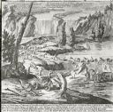
| Date: | 1821 |
|---|---|
| Description: | Indians of the North Red River area, probably in the vicinity of old Fort Douglas, now Winnipeg, Canada, spearing beaver. |

| Date: | 1859 |
|---|---|
| Description: | Color drawing of beavers working on and living at their dams. |
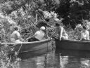
| Date: | |
|---|---|
| Description: | Five women in two boats arrive at a beaver dam while taking a boat ride at Summit Lake Camp. |
| Date: | |
|---|---|
| Description: | Drawing of beavers building a dam. |
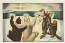
| Date: | 1969 |
|---|---|
| Description: | Holiday card with three couples of animals dancing; two bears, a seal and a beaver, a fox and a rabbit. They are on a snowbank overlooking the sea with the... |

| Date: | 1941 |
|---|---|
| Description: | Hand-drawn, watercolor and ink, map of Lake Mendota. Locations and many small figures appear around the shore with explanations referring to Indian legends... |

| Date: | 1941 |
|---|---|
| Description: | This pictorial map of Wisconsin with historical text highlights the history of the state and identifies places of interest, Indian villages, missions, trad... |
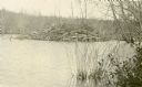
| Date: | |
|---|---|
| Description: | View of a beaver lodge made with tree limbs along the edge of the water. This beaver lodge was located near Nature Lovers Paradise resort on Jackson Lake. ... |
| Date: | |
|---|---|
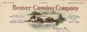
| Description: | Letterhead of the Beaver Canning Company of Randolph, Wisconsin, packers of peas and sweet corn, with three beavers perched on a branch overhanging the wat... |
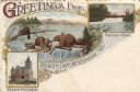
| Date: | 1906 |
|---|---|
| Description: | Color postcard with three illustrations: The Williams Free Library, the dam in 1841 (actual beavers), and the present dam. Captions read: "Greetings From B... |

| Date: | 1720 |
|---|---|
| Description: | One of Herman Moll's most famous maps, often referred to as The Beaver Map for its elaborate engraved inset depicting and describing beavers building a dam... |

| Date: | 1746 |
|---|---|
| Description: | Map of North America from the southern portion of James Bay to Florida. It shows the colonies, cities, Native American land, and topological and geographic... |

| Date: | 1780 |
|---|---|
| Description: | Map of North and South America, showing the boundaries of colonial territories, cities, settlements, rivers, lakes, and Native American land. Particular em... |

| Date: | 1636 |
|---|---|
| Description: | Map of North America, divided into regions, and showing some rivers, lakes, settlements, cities, mountains, and Native American land. Of the Great Lakes on... |

| Date: | 1719 |
|---|---|
| Description: | Map of the Great Lakes and the St. Lawrence river showing French and English cities and villages, trading posts, Indian villages and tribes, portages, for... |

| Date: | 1755 |
|---|---|
| Description: | Large format map of America and Canada east of the Mississippi River. D'Anville marks the locations of rivers, lakes, settlements, cities, Native American ... |

| Date: | 1783 |
|---|---|
| Description: | Map of eastern Canada and part of America, with an inset map of the Great Lakes region in the lower left corner. It shows boundaries, cities, settlements, ... |

| Date: | 1776 |
|---|---|
| Description: | Map showing New England, Nova Scotia, and Newfoundland, based on the seminal work of D' Anville, as well as the works of Belllin and de Vaugondy. It shows ... |
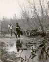
| Date: | 1935 |
|---|---|
| Description: | A warden, wearing high laced boots and leather jodhpurs, is holding a beaver by the tail while standing in shallow water. A second man, wearing waders, is ... |

| Date: | 1910 |
|---|---|
| Description: | View across water toward a stick-based structure, which is situated on the water near a shoreline and forest. Caption identifies it as: "Beaver House on Be... |
If you didn't find the material you searched for, our Library Reference Staff can help.
Call our reference desk at 608-264-6535 or email us at: