 Filter: Categories of Wisconsin Historical Images
Filter: Subject of Bays
Filter: Year of 1800-1899
Filter: Subject of transportation
Filter: Categories of Wisconsin Historical Images
Filter: Subject of Bays
Filter: Year of 1800-1899
Filter: Subject of transportation
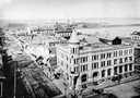
| Date: | 1891 |
|---|---|
| Description: | Elevated view looking west from the Knight Block. The Chequamegon Hotel and harbor are in the background. |

| Date: | 1893 |
|---|---|
| Description: | Bird's-eye map of Sturgeon Bay, looking Northeast. Area bordered by Church Street in top left corner, leather & Smith Bridge in bottom left corner, Lawrenc... |

| Date: | 1880 |
|---|---|
| Description: | Bird's-eye map of Sturgeon Bay. County Seat of Door County. |

| Date: | 1885 |
|---|---|
| Description: | Ore dock of the Milwaukee, Lake Shore, and Western Railroad, with a pile of logs in the foreground and docked ships in the background. |

| Date: | 1885 |
|---|---|
| Description: | View of the ore dock of the Milwaukee, Lake Shore, and Western Railroad. Large logs, buildings and a railroad bridge are in the foreground. |

| Date: | 1856 |
|---|---|
| Description: | A hand-colored map of Wisconsin, showing the county boundaries, towns, cities, railroads, roads, lakes, rivers, bays, and the Lake Superior’s islands. In ... |

| Date: | 1860 |
|---|---|
| Description: | A hand-drawn, ink on cloth map of southeastern Wisconsin that show roads and railroads that connect Chicago to Milwaukee and other towns in the southeaster... |

| Date: | 1853 |
|---|---|
| Description: | Railroad map outlines mid and southern Wisconsin county boundaries in red, and city/town lines are provided. Other marks include lead mines, copper mines, ... |

| Date: | 1886 |
|---|---|
| Description: | This map, originally published in the 1881 Illustrated historical atlas of Wisconsin, shows the township and range system, sections,towns, cities and villa... |

| Date: | 1871 |
|---|---|
| Description: | Asaph Whittlesey arrived in Ashland in 1854, one of the earliest of the settlers who hoped the area would grow and make their fortunes. He drew this map of... |

| Date: | 1872 |
|---|---|
| Description: | This 1872 map shows the proposed route of a canal between Sturgeon Bay, on the Green Bay side of the Door Peninsula, and Lake Michigan. Depths in both Stur... |

| Date: | 1871 |
|---|---|
| Description: | Asaph Whittlesey arrived in Ashland in 1854, one of the earliest of the settlers who hoped the area would grow and make their fortunes. He drew this map of... |

| Date: | 1850 |
|---|---|
| Description: | Map is pen and pencil on paper. The map shows roads, creeks, and the Chequamegon Bay. The map is undated and prepared sometime between the establishment of... |

| Date: | 1890 |
|---|---|
| Description: | This map of Superior shows labeled streets, railroads, docks, city wards, and the state line. Relief is shown by hachures. Below the title reads: "Bedford ... |

| Date: | 1890 |
|---|---|
| Description: | This map of Superior shows city wards, bays, docks, some businesses and points of interest. Relief is shown by hachures. The back of the map features a typ... |

| Date: | 1898 |
|---|---|
| Description: | This map of Superior shows city wards, bays, docks, and some businesses and points of interest. Relief is shown by hachures. The map probably came from a C... |

| Date: | 1860 |
|---|---|
| Description: | This map of Superior is oriented with north to the upper left. Relief is shown by hachures and water depths are shown by soundings. Lake Superior and bays ... |

| Date: | 1887 |
|---|---|
| Description: | This map shows lot and block numbers, established dock lines, docks, slips, railroads, and streets of West Superior in 1887. |

| Date: | 1889 |
|---|---|
| Description: | This map shows lot and block numbers, established dock lines, docks, slips, railroads, and streets of West Superior in 1889. |

| Date: | 1888 |
|---|---|
| Description: | This map shows wards and includes the Chequamegon Bay and Washburn. An inset map shows the Ashland region, its railroads, and a few of its iron mines. |
If you didn't find the material you searched for, our Library Reference Staff can help.
Call our reference desk at 608-264-6535 or email us at: