 Filter: Categories of Wisconsin Historical Images
Filter: Subject of Bays
Filter: Subject of automobiles
Filter: Categories of Wisconsin Historical Images
Filter: Subject of Bays
Filter: Subject of automobiles
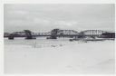
| Date: | 01 06 1958 |
|---|---|
| Description: | View from snowy shoreline of Highway Bridge, the east approach. The lake is frozen. Just beyond the shoreline a boat is moored at a landing, and an automob... |

| Date: | 1932 |
|---|---|
| Description: | This map shows automobile routes across Wisconsin and parts of Illinois, Michigan, Minnesota and Iowa. The Mississippi River, Lake Michigan, Lake Superior,... |

| Date: | 1933 |
|---|---|
| Description: | This road map shows automobile routes across Wisconsin as well as portions of Illinois, Minnesota, Iowa and Michigan. Lakes Michigan, Superior and Winnebag... |

| Date: | 1933 |
|---|---|
| Description: | This map contains automobile routes across Wisconsin and portions of Illinois, Iowa, Minnesota and Michigan as well. The state borders are clearly defined... |

| Date: | 1934 |
|---|---|
| Description: | This map provides automobile routes through Wisconsin along with portions of Illinois, Iowa, Minnesota and Michigan. Lake Superior, Lake Michigan, Green B... |

| Date: | 1934 |
|---|---|
| Description: | This road map contains automobile routes for the state of Wisconsin as well as portions of Minnesota, Illinois, Iowa and Michigan. Lake Michigan, Lake Sup... |
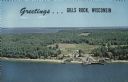
| Date: | |
|---|---|
| Description: | A color aerial view of Gills Rock from Green Bay. Washington Island and Lake Michigan are along the horizon. An excursion boat is docked at the landing. Ca... |
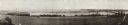
| Date: | 1914 |
|---|---|
| Description: | Panoramic view of Brittingham Bay taken from the north west shore of Brittingham Park. The boathouse is on the left. On the right the railroad tracks cross... |

| Date: | 1940 |
|---|---|
| Description: | A woman wearing a bandana on her head is sitting at a picnic table talking with another woman who is standing in front of a tent-style camping trailer. Bot... |

| Date: | 1964 |
|---|---|
| Description: | Aerial view of the Sampson Plaza apartment complex on West Washington Avenue, with Proudfit Street running along the bottom. Neighborhood House can be seen... |
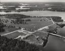
| Date: | 1950 |
|---|---|
| Description: | Aerial view of Northernaire Resort, on Deer Lake. The resort is in the foreground. Many lakes, surrounded by trees, are in the background, including Big St... |
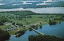
| Date: | 1955 |
|---|---|
| Description: | Text on reverse reads: "Sturgeon Bay Drawbridge Spanning, Sturgeon Bay Canal, Sturgeon Bay, Wis." Traffic is backed up as a ship passes through the span of... |
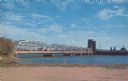
| Date: | 1963 |
|---|---|
| Description: | Text on reverse reads: "Northernaire, Three Lakes, WI 54562. Phone 715 – 546-3331. The Resort Hotel that has it all." Aerial view of Northernaire Resort, o... |
If you didn't find the material you searched for, our Library Reference Staff can help.
Call our reference desk at 608-264-6535 or email us at: