 Filter: Categories of Wisconsin Historical Images
Filter: Subject of Animals
Filter: Subject of coasts
Filter: Categories of Wisconsin Historical Images
Filter: Subject of Animals
Filter: Subject of coasts

| Date: | 1856 |
|---|---|
| Description: | While passing through the English Channel in May 1856 Hölzlhuber viewed the Isle of Wight. "The island is located in the English Channel not far from Hamps... |

| Date: | |
|---|---|
| Description: | Elevated view across beach toward the ship beached in shallow water. There is a crowd of people on the beach in the foreground. Caption reads: "Ship 'Galen... |
| Date: | |
|---|---|
| Description: | View of a stained glass window erected in 1920 in honor of the women of Plymouth Plantation. On the center panel, a ship is in the bay while a man and wom... |
| Date: | |
|---|---|
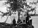
| Description: | A fishermen smoking a pipe poses with fish strung from a wooden pole beneath an evergreen tree. |
| Date: | |
|---|---|
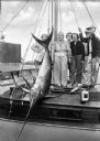
| Description: | Fishermen and women pose with a swordfish tied to a mast aboard a boat. |

| Date: | 1967 |
|---|---|
| Description: | Black and white photographic greeting card. View down beach towards couple hugging while standing in the sand. The word "love" is centered at the top. |

| Date: | 1759 |
|---|---|
| Description: | Map of north eastern Canada and parts of New England, showing settlements, cities, portages, Native American land, mountains, lakes, and rivers. The unusua... |

| Date: | 1783 |
|---|---|
| Description: | Map of eastern Canada and part of America, with an inset map of the Great Lakes region in the lower left corner. It shows boundaries, cities, settlements, ... |

| Date: | 1776 |
|---|---|
| Description: | Map showing New England, Nova Scotia, and Newfoundland, based on the seminal work of D' Anville, as well as the works of Belllin and de Vaugondy. It shows ... |

| Date: | 1719 |
|---|---|
| Description: | Map of Maryland and surrounding states. It shows the boundaries, counties, cities, towns, rivers, and bays. Mountains, forests, and swamps appear pictoria... |

| Date: | 1671 |
|---|---|
| Description: | Map of Virginia depicting the discoveries detailed by John Smith in his exploration of the region. It shows Jamestown, Native American tribes and villages,... |
If you didn't find the material you searched for, our Library Reference Staff can help.
Call our reference desk at 608-264-6535 or email us at: