 Filter: Categories of Wisconsin Historical Images
Filter: Subject of Agriculture
Filter: Subject of wetlands
Filter: Categories of Wisconsin Historical Images
Filter: Subject of Agriculture
Filter: Subject of wetlands
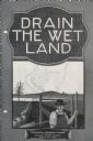
| Date: | 04 15 1930 |
|---|---|
| Description: | Cover of a booklet produced by International Harvester's Agricultural Extension Department. The cover shows a man standing near a drainage ditch. The bookl... |

| Date: | 1914 |
|---|---|
| Description: | This early 20th century map shows the township and range system, sections, railroads, roads, lakes, wetlands, and streams in the western Sawyer County town... |

| Date: | 1878 |
|---|---|
| Description: | This 1878 map of Wood County, Wisconsin, shows the township and range grid, towns, sections, cities, villages and post offices, landownership, roads, railr... |

| Date: | 06 22 1891 |
|---|---|
| Description: | This 1891 manuscript map depicts Cranberry Creek and wetlands in part of the Town of Port Edwards, Wood County, Wisconsin. Elevations and falls in the cree... |
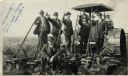
| Date: | 09 08 1914 |
|---|---|
| Description: | Five men in hats and jackets, some holding the levers on a gang plow pulled by a Rumley tractor, pose for a group portrait. One man in work clothes stands ... |

| Date: | 1914 |
|---|---|
| Description: | View of a drainage ditch in Horicon Marsh. A man is on a path along the left of the ditch. |
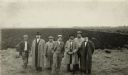
| Date: | 1914 |
|---|---|
| Description: | Group of well-dressed men standing in front of a plowed segment of Horicon Marsh. |

| Date: | 10 1914 |
|---|---|
| Description: | View of furrowed ground in Horicon Marsh and men on a tractor in the process of plowing a drained portion of the marsh. |
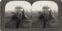
| Date: | |
|---|---|
| Description: | Stereograph showing workers digging a ditch with a tractor and laying drain tile. |

| Date: | 1969 |
|---|---|
| Description: | This photograph was likely taken by the International Harvester Overseas Division for promotional purposes, and shows a man driving an International Harves... |

| Date: | 1862 |
|---|---|
| Description: | This map shows landownership on a military reserve, private claims, buildings (including Fort Howard and U.S. sawmill), swamps, public barns and fields, an... |
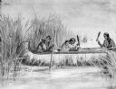
| Date: | |
|---|---|
| Description: | Drawing of three women in a canoe harvesting wild rice. |

| Date: | 1970 |
|---|---|
| Description: | This map shows colored-coded land use with a legend in the bottom margin. Land classifications include: Year-round Residential (yellow), Seasonal Residenti... |

| Date: | 1780 |
|---|---|
| Description: | This map shows the townships, parishes, cities, towns, plantations, lakes, rivers, swamps, and roads near the coast of South Carolina and Georgia. Emphasis... |
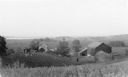
| Date: | 1935 |
|---|---|
| Description: | Elevated view from hill of chickens ranging near their coop behind a farmhouse and outbuildings on a tidy farm. There is a large barn on the right with two... |

| Date: | 1975 |
|---|---|
| Description: | View through snow-covered cattails after a winter snowfall towards a house on the left, and a barn and a silo on the right. |
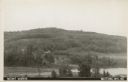
| Date: | 1907 |
|---|---|
| Description: | Text on front reads: "Mount Morris. Wautoma, Wis." A view of Mount Morris from above the shore of a lake or pond. A dwelling and perhaps a farm can be seen... |
If you didn't find the material you searched for, our Library Reference Staff can help.
Call our reference desk at 608-264-6535 or email us at: