 Filter: Categories of Wisconsin Historical Images
Filter: Subject of Agriculture
Filter: Subject of southern states
Filter: Categories of Wisconsin Historical Images
Filter: Subject of Agriculture
Filter: Subject of southern states
| Date: | |
|---|---|
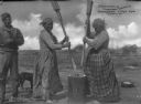
| Description: | A view of two Seminole Native American women grinding corn for "Sofka," a meat stew thickened with vegetables and meal. A man and dog are on the left. Capt... |

| Date: | 1671 |
|---|---|
| Description: | Map of Virginia depicting the discoveries detailed by John Smith in his exploration of the region. It shows Jamestown, Native American tribes and villages,... |

| Date: | 1676 |
|---|---|
| Description: | Map of Virginia and Maryland, based on John Smith's 1612 map and Augustine Herman's 1673 seminal map. It shows borders, counties, Native American land, tri... |

| Date: | 1760 |
|---|---|
| Description: | Map showing the towns, mountains, valleys, corn fields, and rivers of a portion of the Cherokee Nation. A few annotations on the map explain the land and r... |
If you didn't find the material you searched for, our Library Reference Staff can help.
Call our reference desk at 608-264-6535 or email us at: