 Filter: Categories of Wisconsin Historical Images
Filter: Subject of Agriculture
Filter: Subject of great lakes
Filter: Categories of Wisconsin Historical Images
Filter: Subject of Agriculture
Filter: Subject of great lakes

| Date: | 1632 |
|---|---|
| Description: | The Wisconsin portion of Champlain's 1632 map, augmented since the previous one, for navigation according to the true Meridien, by Sieur de Champlain. The ... |

| Date: | 1878 |
|---|---|
| Description: | Map reads: "The P.P. Mast & Co's New Map of Wisconsin, Minnesota, and Northern Iowa". There are various advertisements for P.P. Mast & Co's broad-cast seed... |

| Date: | 1855 |
|---|---|
| Description: | Map reads "Our Country" which is accompanied by a sailor with a flag to the left and workers rejoicing under the Constitution and Laws to the right. Across... |

| Date: | 1906 |
|---|---|
| Description: | A hand-colored commercial map of Wisconsin and portions of eastern Minnesota, Iowa, northern Illinois, and the Michigan’s Upper Peninsula. The map shows ra... |

| Date: | 1952 |
|---|---|
| Description: | Map of the barley-growing regions of North America, published by the Rahr Malting Company, Manitowoc, Wisconsin, 1952. |
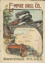
| Date: | 1901 |
|---|---|
| Description: | Catalog cover with the title: "The Three Greatest Empires," features an illustration of an Empire Drill in the foreground, and in the background a train tr... |

| Date: | 1923 |
|---|---|
| Description: | This map includes an explanation that reads: "This chart shows the movement of barley on the Great Lakes, St. Lawrence River, and New York State Barge Cana... |

| Date: | 1923 |
|---|---|
| Description: | This map includes an explanation that reads: "This chart shows the movement of corn on the Great Lakes, St. Lawrence River, and New York State Barge Canal ... |

| Date: | 1923 |
|---|---|
| Description: | This map includes an explanation that reads: "This chart shows the easterly movement of flaxseed on the Great Lakes, St. Lawrence River, and New York State... |

| Date: | 1923 |
|---|---|
| Description: | This map includes an explanation that reads: "This chart shows the movement of grain on the Great Lakes, St. Lawrence River, and New York State Barge Canal... |

| Date: | 1923 |
|---|---|
| Description: | This map includes an explanation that reads: "This chart shows the movement of oats on the Great Lakes, St. Lawrence River, and New York State Barge Canal ... |

| Date: | 1923 |
|---|---|
| Description: | This map includes an explanation that reads: "This chart shows the movement of rye on the Great Lakes, St. Lawrence River, and New York State Barge Canal d... |

| Date: | 1923 |
|---|---|
| Description: | This map includes an explanation that reads: "This chart shows the movement of wheat on the Great Lakes, St. Lawrence River, and New York State Barge Canal... |

| Date: | 1872 |
|---|---|
| Description: | This map includes depth shown by soundings and isolines and relief shown by contours. Tree species and locations are labeled, as well as a cranberry meadow... |

| Date: | 1685 |
|---|---|
| Description: | A detailed map of the western hemisphere showing cities, settlements, Native American land, rivers, lakes, mountains, the Great Lakes, and California as an... |
If you didn't find the material you searched for, our Library Reference Staff can help.
Call our reference desk at 608-264-6535 or email us at: