 Filter: Categories of Wisconsin Historical Images
Filter: FULL_DATE of 1955
Filter: Subject of transportation
Filter: Subject of botany
Filter: County of Dane
Filter: Categories of Wisconsin Historical Images
Filter: FULL_DATE of 1955
Filter: Subject of transportation
Filter: Subject of botany
Filter: County of Dane
| Date: | 1955 |
|---|---|
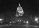
| Description: | A nighttime view of the Wisconsin State Capitol as seen from Monona Avenue (South Wisconsin Avenue until December 1, 1877; Martin Luther King Jr. Boulevard... |

| Date: | 1955 |
|---|---|
| Description: | Aerial view of Cross Plains, with countryside surrounding and hills on the horizon. |

| Date: | 1955 |
|---|---|
| Description: | Aerial view of Atwood Avenue, looking west towards Winnebago Street and "Schenk's Corners." |

| Date: | 1955 |
|---|---|
| Description: | Exterior view of Central High School with cars parked in front. |

| Date: | 1955 |
|---|---|
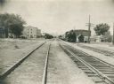
| Description: | Chicago and Northwestern Railroad (CN&W) tracks between Brearly and Ingersoll Streets. |
| Date: | 1955 |
|---|---|
| Description: | Chicago and North Western Railroad (CN&W) tracks between Brearly and Ingersoll Streets. |
| Date: | 1955 |
|---|---|
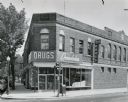
| Description: | The Rennebohm Drug Store #5, located at 2000 Atwood Avenue, Schenk's Corners from 1952-1961. It was previously located at 1951 Winnebago Street. This store... |
| Date: | 1955 |
|---|---|
| Description: | West Doty Street, from Monona Avenue looking toward South Carroll Street, showing the back side of Madison Newspapers, Inc. The building was added on to in... |
| Date: | 1955 |
|---|---|
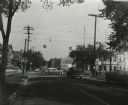
| Description: | The intersection of Johnson and Broom Streets. |

| Date: | 1955 |
|---|---|
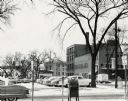
| Description: | Elevated view looking west at Washington School, located at 217 North Broom Street. From the early 1940's until its demolition in 1957, the school was used... |

| Date: | 1955 |
|---|---|
| Description: | Aerial view of Schenk's Corners where Atwood Avenue and Winnebago Street cross, looking north west toward East Washington Avenue. ... |

| Date: | 1955 |
|---|---|
| Description: | State patrol officers line up beside their patrol cars at Old District 1 State Patrol Field Headquarters on Highway 12. They appear to be receiving instruc... |

| Date: | 1955 |
|---|---|
| Description: | An aerial view of Middleton. In the foreground is a baseball field, and beyond are houses, woods, fields, and Lake Mendota. |

| Date: | 1955 |
|---|---|
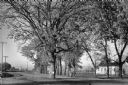
| Description: | Aerial view, looking west from over Hoyt Park toward Midvale Boulevard. |

| Date: | 1955 |
|---|---|
| Description: | View across Mifflin Street, towards Madison City Hall as it is being demolished. On the street women are walking around the construction to get to the side... |
| Date: | 1955 |
|---|---|
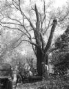
| Description: | A large, spreading bur oak standing directly in the intersection of Hammond and Hanerville Roads, both unpaved. There is a row of smaller trees lining Hane... |
| Date: | 1955 |
|---|---|
| Description: | Workers strain to move a heavy limb which has been cut from the large black locust tree which grew along Observatory Drive on the University of Wisconsin c... |

| Date: | 1955 |
|---|---|
| Description: | View across street towards Josie's Restaurant, at 906 Regent Street. The eatery was owned by the Schuepbach-Jensen family between 1964 and 2007, before bei... |
If you didn't find the material you searched for, our Library Reference Staff can help.
Call our reference desk at 608-264-6535 or email us at:

