 Filter: Categories of Wisconsin Historical Images
Filter: FULL_DATE of 1900
Filter: Type of Map or Atlas
Filter: Categories of Wisconsin Historical Images
Filter: FULL_DATE of 1900
Filter: Type of Map or Atlas

| Date: | 1900 |
|---|---|
| Description: | This map shows railroad routes in red, blue, orange, brown, pink, green, and dotted, as well as lakes, rivers, and communities. The map includes a legend i... |
| Date: | 1900 |
|---|---|
| Description: | This map show land parcels and roads located along Swan Lake. Original map caption reads: "Sixth day of October A.D. 1836." |
| Date: | 1900 |
|---|---|
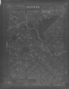
| Description: | This map shows the blocks and streets that make up the village, and includes the Baraboo Air Line Railroad which cuts through the village at a diagonal fro... |

| Date: | 1900 |
|---|---|
| Description: | This map shows the additions made in January 1855, as well as houses, streets, Catfish Creek, and the Milwaukee and Mississippi Rail Road and Depot. It als... |
| Date: | 1900 |
|---|---|
| Description: | This map shows distances along the road, rivers, Indian trails between a shantytown south of Navarino (Green Bay)and Fort Howard. It also shows Lake Winneb... |

| Date: | 1900 |
|---|---|
| Description: | This map shows landownership circa 1848 in the old Stockbridge Indian reservation on Lake Winnebago in Calumet County. It is oriented with north to the lef... |
| Date: | 1900 |
|---|---|
| Description: | This map shows a paper city located in section 23, township 17 north, range 22 east; area now occupied by the community of Spring Valley in Manitowoc Count... |

| Date: | 1900 |
|---|---|
| Description: | This manuscript cadastral map shows Sheboygan Falls under its earlier name of Rochester. It shows land parcels, the Sheboygan River, roads, and parks. The ... |

| Date: | 1900 |
|---|---|
| Description: | This map shows a proposed route of for a road linking military forts. The map also includes communities, lakes, and rivers. The map is accompanied by a rep... |

| Date: | 1900 |
|---|---|
| Description: | This map shows AS&IR Railroad between Siskiwit and Nash (with dock), a proposed extension of AS&IR Railroad "now under construction" between Superior and N... |

| Date: | 1900 |
|---|---|
| Description: | This map shows a paper city located on Swan Lake in Columbia County. It includes lot and block numbers, two public squares, and two little lakes of "good w... |

| Date: | 1900 |
|---|---|
| Description: | This map shows the boundary lines between ceded and unceded land in compliance with the Treaty of Prairie du Chen of 1829. It also shows roads, rivers, por... |
| Date: | 1900 |
|---|---|
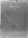
| Description: | This map shows names, plot numbers, and payment status. The bottom right margin reads: "Surveyed April 28 & 29, 1879. Platted May 20." |

| Date: | 1900 |
|---|---|
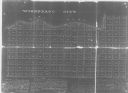
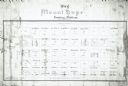
| Description: | This map shows landownership, churches, schools, farm houses, wagon roads, railroads, and townships and includes businesses advertisements, tables of stati... |
| Date: | 1900 |
|---|---|
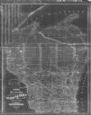
| Description: | This map shows county boundaries, towns, waterways,towns, railroads and proposed railroads, Lake Michigan and Superior. A Portion of Michigan is visible. O... |
| Date: | 1900 |
|---|---|
| Description: | This map shows land purchased by Solomon Juneau on Sept. 29, 1847, according to U.S. Land Office, local office tract books, Wisconsin, volume 70. Juneauvil... |
| Date: | 1900 |
|---|---|
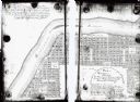
| Description: | This map shows lots, public squares, landing, streets, and promenade of a paper city on a site now in the Town of West Point, Columbia County. The Wisconsi... |

| Date: | 1900 |
|---|---|
| Description: | This map shows a line, marked with latitude and longitude coordinates that runs through Prairie du Chien. Only a few features beyond this line are displaye... |

| Date: | 1900 |
|---|---|
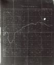
| Description: | This map shows distances and land use along Dekorra and Sauk-Harbour road. It covers road between areas currently known as Dekorra and Port Washington, Wis... |

| Date: | 1900 |
|---|---|
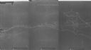
| Description: | This map shows portion of the military road from Fond du Lac to the Wisconsin River near Fort Winnebago, with mile markers and adjacent land use. A few pro... |
If you didn't find the material you searched for, our Library Reference Staff can help.
Call our reference desk at 608-264-6535 or email us at: