 Filter: Categories of Wisconsin Historical Images
Filter: FULL_DATE of 1873
Filter: Subject of church buildings
Filter: Categories of Wisconsin Historical Images
Filter: FULL_DATE of 1873
Filter: Subject of church buildings
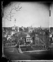
| Date: | 1873 |
|---|---|
| Description: | View, ca. 1873-1879, of Madison looking down Wisconsin Avenue toward the third Wisconsin Capitol, a view that suggests something of the ongoing importance ... |
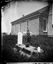
| Date: | 1873 |
|---|---|
| Description: | Norwegian-American farm laborer, Hans Christianson (age 44), stands next to the grave of his childless wife, Karen Luis Christianson, born 1829, who died J... |
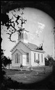
| Date: | 1873 |
|---|---|
| Description: | Finely detailed frame church with vestibule and steeple, enclosed with picket fencing with a hitching post in front. |
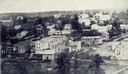
| Date: | 1873 |
|---|---|
| Description: | View of Bloomington by the pioneer photographer of the village, Frank Witcomb, sometime after 1873. There are buildings identified in the foreground on bot... |
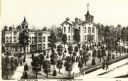
| Date: | 1873 |
|---|---|
| Description: | The Lake Geneva Seminary, founded June 10, 1869 and was chartered by an act of legislature on March 1871. |

| Date: | 1873 |
|---|---|
| Description: | This late 19th century map shows the lake region around Oconomowoc in Waukesha County and eastern Jefferson County, Wisconsin. The township and range grid,... |

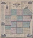
| Date: | 1873 |
|---|---|
| Description: | This 1873 map of Chippewa County, Wisconsin, which at the time also encompassed all or part of Price, Rusk, Sawyer, and Taylor counties, shows the township... |

| Date: | 1873 |
|---|---|
| Description: | This 1874 map of Washington and Ozaukee counties, Wisconsin, shows the township and range grid, towns, sections, cities and villages, rural landownership a... |

| Date: | 1873 |
|---|---|
| Description: | This 1873 map of Winnebago County, Wisconsin, shows the township and range grid, towns, sections, cities and villages, landownership and acreages, roads, r... |

| Date: | 1873 |
|---|---|
| Description: | Map shows townships and sections, landownership and acreages, state and county lands, churches, schools, cemeteries, roads, and railroads. There is an inse... |

| Date: | 1873 |
|---|---|
| Description: | This map shows landownership and acreages, lot and block numbers, roads and railroads, marshes, schools, churches, mills, rural buildings, and quarries. Re... |

| Date: | 1873 |
|---|---|
| Description: | Elevated view from Capitol Park of Madison City Hall with clock tower, 2 West Mifflin Street. Lake Mendota is in the far background. |
| Date: | 1873 |
|---|---|
| Description: | This hand-colored map includes business directories, a statistical table, as well as illustrations of public, residential, and commercial properties. Commu... |
If you didn't find the material you searched for, our Library Reference Staff can help.
Call our reference desk at 608-264-6535 or email us at: