Filter: Categories of Wisconsin Historical Images
Filter: FULL_DATE of 1858
Filter: Subject of architecture
Filter: Categories of Wisconsin Historical Images
Filter: FULL_DATE of 1858
Filter: Subject of architecture
| Date: | 1858 |
|---|---|
| Description: | Ambrotype of the Wade House, a carriage inn located in Greenbush, also showing a section of the original plank road in the foreground. |

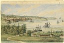
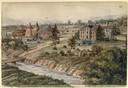
| Date: | 1858 |
|---|---|
| Description: | Elevated view from bluff looking down on city, with Lake Michigan in background. Detailed foreground with two boys playing with a grounded kite, while a ma... |
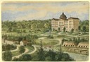
| Date: | 1858 |
|---|---|
| Description: | View from the second story of the Salesianum, the residence of Dr. Salzmann. The view includes Lake Michigan, the Milwaukee shoreline, and some of the nume... |
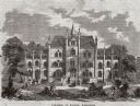
| Date: | 1858 |
|---|---|
| Description: | A Catholic seminary since 1854, the Salesianum was built by Dr. Salzmann, a Catholic missionary from Munzbach in upper Austria. A two-hour walk from the ci... |
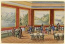
| Date: | 1858 |
|---|---|
| Description: | A depiction of groups of people viewing a panorama of landscapes on red walls in a large room, some seated at round tables. This sketch accompanies an Aust... |
| Date: | 1858 |
|---|---|
| Description: | A view of the Synagogue with a one-horse carriage in the foreground. Hölzlhuber occupied the position of organist and choirmaster for this congregation unt... |
| Date: | 1858 |
|---|---|
| Description: | Hölzlhuber located this farm at about three German miles from Stevens Point. The region's soil was quite fertile. A wooden dwelling house stood in the mids... |

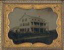
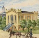
| Date: | 1858 |
|---|---|
| Description: | The U.S. Hotel was constructed in 1852 by Hugh Phillips to be used for mercantile purposes, but later transformed into the hotel. A group of people are sta... |
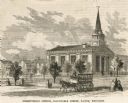
| Date: | 1858 |
|---|---|
| Description: | View of a Presbyterian church with a horse-drawn vehicle and multiple pedestrians in the foreground. Caption reads: "Presbyterian Church, Barnstable Street... |
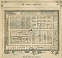
| Date: | 1858 |
|---|---|
| Description: | Diagram drawing of a kitchen vegetable garden. |

| Date: | 1858 |
|---|---|
| Description: | An ink on paper map of Milwaukee County and the eastern portion of Waukesha County that shows the townships of Oak Creek, Franklin, Greenfield, Wauwatosa, ... |

| Date: | 1858 |
|---|---|
| Description: | This 1858 map of Racine County, Wisconsin, shows land ownership and acreages, the township and range grid, towns, cities and villages, roads, railroads, sc... |

| Date: | 1858 |
|---|---|
| Description: | This 1858 map of Rock County, Wisconsin, shows the township and range grid, towns, sections, cities and villages, railroads, roads, property owners and res... |

| Date: | 1858 |
|---|---|
| Description: | This map is hand-colored and mounted on cloth and shows lot and block numbers and dimensions, landownership, streets, railroads, selected buildings, fair g... |
If you didn't find the material you searched for, our Library Reference Staff can help.
Call our reference desk at 608-264-6535 or email us at: