 Filter: Categories of Wisconsin Historical Images
Filter: FULL_DATE of 1855
Filter: Subject of military art and science
Filter: Categories of Wisconsin Historical Images
Filter: FULL_DATE of 1855
Filter: Subject of military art and science

| Date: | 1855 |
|---|---|
| Description: | Fox-Wisconsin portage and canal map, when the canal was not yet built. From a map in the office of the city clerk at Portage. "The old trail, the location ... |
| Date: | 1855 |
|---|---|
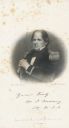
| Description: | Engraved portrait of Matthew Fontaine Maury (1806-1873) American astronomer, historian, oceanographer, meteorologist, cartographer, author, geologist, and ... |

| Date: | 1855 |
|---|---|
| Description: | Map reads "Our Country" which is accompanied by a sailor with a flag to the left and workers rejoicing under the Constitution and Laws to the right. Across... |
| Date: | 1855 |
|---|---|
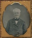
| Description: | Sixth plate daguerreotype of a waist-up seated portrait of Col. John Johnston. Johnston is pictured here as an elderly man; however, he is remembered in Wi... |

| Date: | 1855 |
|---|---|
| Description: | This map shows landownership, lot and block numbers, streets, a canal, bridges, Fort Winnebago, the Wisconsin River, and the Fox River. Relief is shown by ... |
| Date: | 1855 |
|---|---|
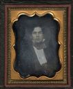
| Description: | An eighth plate daguerreotype of Edward P. Bridgman, 1834-1915, as a young man. Bridgman served in the 37th Massachusetts volunteer Infantry, Company G in ... |
If you didn't find the material you searched for, our Library Reference Staff can help.
Call our reference desk at 608-264-6535 or email us at: