 Filter: Categories of Wisconsin Historical Images
Filter: FORMAT_TYPE of prints, photomechanical
Filter: Year of 1900-1999
Filter: Community of Madison
Filter: Categories of Wisconsin Historical Images
Filter: FORMAT_TYPE of prints, photomechanical
Filter: Year of 1900-1999
Filter: Community of Madison

| Date: | 1908 |
|---|---|
| Description: | Colored map showing a panoramic view of Madison in great detail. The Wisconsin State Capitol is located at the center, with Lake Mendota in the background ... |
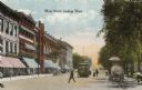
| Date: | 1900 |
|---|---|
| Description: | View down Main Street on the Capitol Square. Caption reads: "Main Street, looking West." |
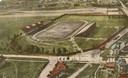
| Date: | 1908 |
|---|---|
| Description: | Colorized aerial view of Camp Randall Stadium at the University of Wisconsin-Madison. |
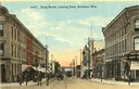
| Date: | 1910 |
|---|---|
| Description: | Colorized view of King Street, looking east, with a streetcar. Lake Monona is in the background. Caption reads: "King Street, looking East, Madison, Wis." |

| Date: | 1924 |
|---|---|
| Description: | Unexecuted design by Frank Lloyd Wright of Nakoma Country Club, for which the architect received a fee of $5,000. |

| Date: | 1910 |
|---|---|
| Description: | Map of Dane County rural delivery in Madison and the town of Westport. |

| Date: | 1916 |
|---|---|
| Description: | Map of all automobile roads out of Madison, compliments of the Madison Board Of Commerce. |

| Date: | 1910 |
|---|---|
| Description: | Map of the general plan of the district of the Four Lakes. |
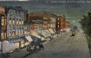
| Date: | 1910 |
|---|---|
| Description: | Elevated view at night of streetcars moving along the Capitol Square on Pinckney Street. Walzinger's Drugstore is one of the prominent storefronts on the l... |
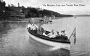
| Date: | 1915 |
|---|---|
| Description: | View of a group of people in a large model launch with an American flag. Caption reads: "On Mendota Lake near University of Wisconsin-Madison Boat House." |
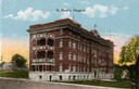
| Date: | 1915 |
|---|---|
| Description: | St. Mary's Hospital soon after its completion in 1911. Caption reads: "St. Mary's Hospital." |
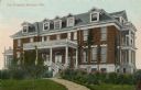
| Date: | 1910 |
|---|---|
| Description: | View of City Hospital, which became known as Madison General Hospital and is now Meriter Hospital. It was designed by Madison architects Louis W. Claude an... |
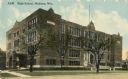
| Date: | 1915 |
|---|---|
| Description: | Central High School, designed by St. Paul architect Cass Gilbert and partially razed in 1986. Caption reads: "High School, Madison, Wis." |

| Date: | 1949 |
|---|---|
| Description: | Color bird's-eye map of the University of Wisconsin-Madison as it was midcentury, with two co-eds, several photographs of campus landmarks around edges, an... |

| Date: | 1948 |
|---|---|
| Description: | Colored map with black and white photographic images in wedges at right and left sides. Map extends from Camp Randal stadium at bottom left corner, to Lake... |
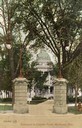
| Date: | 1909 |
|---|---|
| Description: | View of one of the four Prairie du Chien stone gateways that stood at the four corner entrances to the Capitol Park. More elaborate gates topped with iron ... |

| Date: | 1904 |
|---|---|
| Description: | Postcard depicting the fire of February 26-27, 1904 that destroyed most of the second Wisconsin State Capitol. The smoke and flames have been dramatically ... |

| Date: | 1929 |
|---|---|
| Description: | Bird's-eye map of the University of Wisconsin-Madison on Lake Mendota. Black and white drawing with named streets and numbered buildings without location ... |
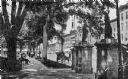
| Date: | 1912 |
|---|---|
| Description: | This card which is postmarked 1912 shows the zinc statutes on the stone gateways near the sidewalk at Monona Avenue (now Martin Luther King Jr. Blvd.). Ori... |
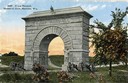
| Date: | 1912 |
|---|---|
| Description: | Camp Randall Memorial Arch and Civil War cannons. The memorial was built to honor Wisconsin Civil War soldiers and is located on the University of Wisconsi... |
If you didn't find the material you searched for, our Library Reference Staff can help.
Call our reference desk at 608-264-6535 or email us at: