 Filter: Categories of Wisconsin Historical Images
Filter: FORMAT_TYPE of prints, photomechanical
Filter: Subject of marshes
Filter: Categories of Wisconsin Historical Images
Filter: FORMAT_TYPE of prints, photomechanical
Filter: Subject of marshes
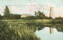
| Date: | 1898 |
|---|---|
| Description: | Caption reads: "Old Stone Tower and House, Long Tail Point, Green Bay, Wis." Water and a marshy area are in the foreground. |
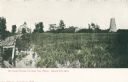
| Date: | 1910 |
|---|---|
| Description: | Caption reads: "Old Light House at Long Tail Point, Green Bay, Wis." Built in 1859. A marshy area is in the foreground, and a long pier leads to the new li... |
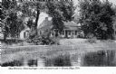
| Date: | 1907 |
|---|---|
| Description: | View across water toward the Tank Cottage. Caption reads: "The Historic Tank Cottage — over 100 years old — Green Bay, Wis." |

| Date: | 1840 |
|---|---|
| Description: | This map surveyed under the direction of Captain Thomas J. Cram is one in a series of seventeen that accompanied Cram's report on the Fox-Wisconsin river s... |

| Date: | 1972 |
|---|---|
| Description: | This map on 5 sheets features a title page sheet with business directory and shows section numbers, roads, railroads, saw mills, churches, blacksmith shops... |

| Date: | 1847 |
|---|---|
| Description: | A hand-colored map that shows the area south and east of the Wisconsin and Fox Rivers, as well as a few landmarks just north of that area. The township gri... |

| Date: | 1839 |
|---|---|
| Description: | This map shows the township and section grid, lakes, rivers, swamps, prairies, roads, and proposed canals in the area of Wisconsin south of Lake Winnebago ... |

| Date: | 1840 |
|---|---|
| Description: | This hand-colored map shows the township and section grid in southeastern Wisconsin, covering the area west to Sugar River and Four Lakes region and north ... |

| Date: | 1855 |
|---|---|
| Description: | This map shows the township survey grid and identifies counties, named towns, rivers, lakes, railroads, and proposed railroads,. Horicon Marsh is labeled H... |

| Date: | 1856 |
|---|---|
| Description: | This map with an ornamental border shows the township survey grid and identifies counties, named towns, cities and villages, rivers, lakes, railroads, road... |

| Date: | 1856 |
|---|---|
| Description: | This map of shows the township survey grid and identifies counties, named towns, cities and villages, rivers, lakes, railroads, roads, and the Menomonee an... |

| Date: | 1857 |
|---|---|
| Description: | This map depicts the township survey grid and identifies counties, named towns, cities and villages, rivers, lakes, railroads, roads, and the Menomonee and... |

| Date: | 1857 |
|---|---|
| Description: | This map depicts the township survey grid in Wisconsin and northern Michigan and identifies counties, named towns, cities and villages, rivers, lakes, rail... |

| Date: | 1858 |
|---|---|
| Description: | This map shows the township survey grid and identifies counties, named towns, cities and villages, rivers, lakes, and railroads and proposed railroads in W... |

| Date: | 1858 |
|---|---|
| Description: | This map of the entire state of Wisconsin depicts the township survey grid and identifies counties, named towns, cities and villages, rivers, lakes, railro... |

| Date: | 1859 |
|---|---|
| Description: | This map of the entire state of Wisconsin depicts the township survey grid and identifies counties, named towns, cities and villages, rivers, lakes, railro... |

| Date: | 1861 |
|---|---|
| Description: | This map of the entire state of Wisconsin depicts the township survey grid and identifies counties, named towns, cities and villages, rivers, lakes, railro... |

| Date: | 1864 |
|---|---|
| Description: | This map of the entire state of Wisconsin depicts the township survey grid and identifies counties, named towns, cities and villages, rivers, lakes, railro... |

| Date: | 1865 |
|---|---|
| Description: | This map of the entire state of Wisconsin depicts the township survey grid and identifies counties, named towns, cities and villages, rivers, lakes, railro... |

| Date: | 1871 |
|---|---|
| Description: | This map of Wisconsin and surrounding states depicts the township survey grid and identifies counties, named towns, cities and villages, rivers, lakes, rai... |
If you didn't find the material you searched for, our Library Reference Staff can help.
Call our reference desk at 608-264-6535 or email us at: