 Filter: Categories of Wisconsin Historical Images
Filter: FORMAT_TYPE of prints, fine-art
Filter: Subject of persons
Filter: Subject of indians of north america
Filter: Year of 1700-1799
Filter: Categories of Wisconsin Historical Images
Filter: FORMAT_TYPE of prints, fine-art
Filter: Subject of persons
Filter: Subject of indians of north america
Filter: Year of 1700-1799
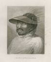
| Date: | 1784 |
|---|---|
| Description: | Plate 48. Portrait from Cook's Third Expedition, 1776-1779, while in Alaska. |
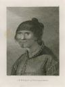
| Date: | 1784 |
|---|---|
| Description: | Plate 49. Portrait from Cook's Third Expedition, 1776-1779, while in Alaska. |

| Date: | 1718 |
|---|---|
| Description: | This map shows the Mississippi River, with latitude and longitude coordinates, ad covers east to Lake Ontario and south to Illinois. The inset map (the top... |

| Date: | 1746 |
|---|---|
| Description: | Map of North America from the southern portion of James Bay to Florida. It shows the colonies, cities, Native American land, and topological and geographic... |

| Date: | 1780 |
|---|---|
| Description: | This map shows the northern Pacific Ocean with North America and Asia, with cities and geographical features labeled, as well Russian, French and Spanish r... |

| Date: | 1758 |
|---|---|
| Description: | This map of the north-west hemisphere shows the cities, lakes, rivers, mountains, and political borders. In the upper left corner sits a decorative cartouc... |

| Date: | 1755 |
|---|---|
| Description: | This map shows the eastern half of North America during the French and Indian war, including cities, borders, Native American Land, forts, and detailed geo... |

| Date: | 1783 |
|---|---|
| Description: | This map is hand-colored and shows the boundaries of British, Spanish, and the newly recognized American claims, as well as the fishing rights granted to F... |

| Date: | 1746 |
|---|---|
| Description: | Detailed map of the western hemisphere and part of Africa and Europe. Islands, cities, settlements, rivers, lakes, countries, and regions are marked. Mount... |

| Date: | 1759 |
|---|---|
| Description: | Map of North and South America showing regions, colonies, cities and settlements, rivers, lakes, and Native American land. Near the bottom left an inset ma... |

| Date: | 1780 |
|---|---|
| Description: | Map of North and South America, showing the boundaries of colonial territories, cities, settlements, rivers, lakes, and Native American land. Particular em... |

| Date: | 1710 |
|---|---|
| Description: | Map of North America showing the European claims, Native American land and villages, rivers, lakes, cities, and notes on explorers, discoveries, and topogr... |

| Date: | 1719 |
|---|---|
| Description: | This extremely detailed and ornate map shows the cities, Native American land, mountains, lakes, rivers, and European claims of North America. An inset map... |

| Date: | 1719 |
|---|---|
| Description: | Map of North America showing land divisions between France, Spain, England, Sweden, Denmark and Holland. The map is detailed, labeling cities, forts, islan... |

| Date: | 1760 |
|---|---|
| Description: | Map of North America based upon the cartographic work of de L'Isle. It shows cities, regions, lakes, rivers, Native American land, mountains, islands, and ... |

| Date: | 1766 |
|---|---|
| Description: | This map of North America shows the boundaries of European claims at the end of the French and Indian war. The British colonies extend to the Mississippi. ... |

| Date: | 1733 |
|---|---|
| Description: | This map of North America shows settlements, rivers, lakes, Native American land, trade winds, and numerous topographical features such as forests and moun... |

| Date: | 1770 |
|---|---|
| Description: | Map of North America from the Great Lakes to the northern portion of South America. It shows cities, Native American land, mountains, swamps, lakes, rivers... |

| Date: | 1740 |
|---|---|
| Description: | Map including the regions and cities of the northern half of North America. Native American land, rivers, lakes, mountains are labeled. Mountains, marshes,... |

| Date: | 1759 |
|---|---|
| Description: | Map of north eastern Canada and parts of New England, showing settlements, cities, portages, Native American land, mountains, lakes, and rivers. The unusua... |
If you didn't find the material you searched for, our Library Reference Staff can help.
Call our reference desk at 608-264-6535 or email us at: