 Filter: Categories of Wisconsin Historical Images
Filter: FORMAT_TYPE of prints, fine-art
Filter: Subject of military camps
Filter: Categories of Wisconsin Historical Images
Filter: FORMAT_TYPE of prints, fine-art
Filter: Subject of military camps
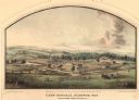
| Date: | 05 1864 |
|---|---|
| Description: | Lithograph of Camp Randall, where the majority of Wisconsin's soldiers were trained and mustered into the Union Army. This view, which was taken from Basc... |
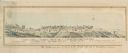
| Date: | 1862 |
|---|---|
| Description: | "Camp Casey near Fairfax Seminary, Virginia 1st Brigade, Casey's Division". Handcolored lithograph of site of Camp Casey. |
| Date: | 1860 |
|---|---|
| Description: | A rare "risque" (for the time) design. A row of soldiers look away from their officer at a young lady as she lifts her skirts to step over a puddle, exposi... |
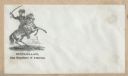
| Date: | 1860 |
|---|---|
| Description: | Union General George McClellan seated on a rearing horse. His saber is drawn and held over his head. A military camp appears in the background. Black ink o... |
| Date: | 1860 |
|---|---|
| Description: | An old woman, stooped over and holding a cane, has Union soldiers ("NORTH" on the left) and Confederate soldiers ("SOUTH" on the right) climbing ladders to... |
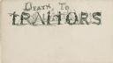
| Date: | 1860 |
|---|---|
| Description: | The letters to the words "DEATH TO TRAITORS" are made up of soldiers, Confederate flags, gallows, a hanged man and guns. A military camp is visible in the ... |
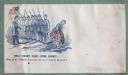
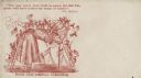
| Date: | 1860 |
|---|---|
| Description: | Envelope depicts a Zouave camp with five soldiers relaxing around a campfire in front of a tent. A tree branch and a drum are in the foreground. The captio... |

| Date: | 1942 |
|---|---|
| Description: | Holiday card showing a military camp with three soldiers standing together gazing at the Christmas star. Two tents are pitched under two trees on the shore... |

| Date: | 1900 |
|---|---|
| Description: | This map shows portion of the military road from Fond du Lac to the Wisconsin River near Fort Winnebago, with mile markers and adjacent land use. A few pro... |

| Date: | 10 1776 |
|---|---|
| Description: | Broadside map showing the British invasion of New York city in August and September of 1776. The map shows important cities, forts, roads, hills, mountains... |

| Date: | 02 1777 |
|---|---|
| Description: | Map depicting the campaigns of October and November 1776, in Manhattan, Westchester, and part of New Jersey, published only a few months after the conclusi... |

| Date: | 03 1777 |
|---|---|
| Description: | Map showing the British and Hessian attack on Fort Washington in November of 1776. The movements and fortifications of the British and Hessian troops appea... |

| Date: | 04 1777 |
|---|---|
| Description: | Map showing the area from Newtown, Pennsylvania to Kingston, New Jersey, with routes and battles of British (red) and American forces (blue). The map inclu... |
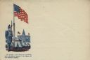
| Date: | |
|---|---|
| Description: | Letterhead with a Union soldier standing guard, rifle in his right arm, beside the American flag. Four tents, representing a military camp, are pitched bet... |
If you didn't find the material you searched for, our Library Reference Staff can help.
Call our reference desk at 608-264-6535 or email us at: