Filter: Categories of Wisconsin Historical Images
Filter: FORMAT_TYPE of prints, fine-art
Filter: Subject of intellectual life
Filter: Subject of agriculture
Filter: Categories of Wisconsin Historical Images
Filter: FORMAT_TYPE of prints, fine-art
Filter: Subject of intellectual life
Filter: Subject of agriculture
| Date: | |
|---|---|
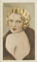
| Description: | Anna Neagle [Florence Marjorie Robertson] (1904-1986), started as a dancer and became a popular film actress. |
| Date: | |
|---|---|
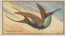
| Description: | The hummingbird is a small New World bird of the family Trochilidae. It has iridescent plumage, a long, slender beak, and rapidly beating wings, which ena... |
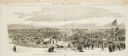
| Date: | 10 24 1863 |
|---|---|
| Description: | Panoramic wood-engraving of a cattle fair in New Haven, after a sketch by H.C. Curtis. Caption reads: "Cattle Show and Agricultural Faib [sic] at Ha... |
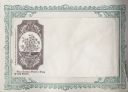
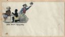
| Date: | 1860 |
|---|---|
| Description: | Cotton plant within a decorative frame. The caption below reads "The Cotton Plant — King of the South." Black ink on beige envelope, image appears on the l... |
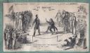
| Date: | 1860 |
|---|---|
| Description: | Abraham Lincoln and Jefferson Davis in a boxing ring. Text at top reads, "CHAMPION PRIZE ENVELOPE - LINCOLN & DAVIS IN 5 ROUNDS," underneath reads "1ST ROU... |
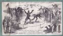
| Date: | 1860 |
|---|---|
| Description: | Abraham Lincoln and Jefferson Davis in a boxing ring. Text at top reads, "CHAMPION PRIZE ENVELOPE - LINCOLN & DAVIS IN 5 ROUNDS," underneath reads "2ND ROU... |
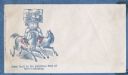
| Date: | 1860 |
|---|---|
| Description: | John Bull is carrying a bale of cotton on his shoulders. He is standing with one foot on each of two galloping horses. One horse labeled "UNION" has a Unio... |
| Date: | 1860 |
|---|---|
| Description: | The Devil sits on a bale labeled "COTTON." "No. 1" appears in the upper left corner. To the right is a verse that reads: "The Devil he sat with his c... |
| Date: | 1860 |
|---|---|
| Description: | Two images of Jefferson Davis within a rope forming a figure eight. At the top, Davis is standing proudly in a uniform holding a sword. The skull and cross... |
| Date: | 1860 |
|---|---|
| Description: | A slave is being whipped by a slave owner as he kneels and prays next to a bale of cotton labeled "COTTON" and "CSA." John Bull sits on the bale facing awa... |
| Date: | 1570 |
|---|---|
| Description: | Frontispiece for Abraham Ortelius' Theatrum Orbis Terrarum, published in 1570, and considered the first modern atlas. Title is surrounded by four figures r... |

| Date: | 1937 |
|---|---|
| Description: | Pictorial map showing historical events and locations within the state of Wisconsin, as well as waterways and counties. Original caption on the bottom marg... |
| Date: | 1923 |
|---|---|
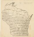
| Description: | This map shows the county boundaries, with each dot representing 50 silos. |

| Date: | 1920 |
|---|---|
| Description: | This map shows lands owned by the American Immigration Company (red) and the Homeseekers Land Company (green). The map also shows highways, roads, railroad... |

| Date: | 1925 |
|---|---|
| Description: | This map shows trails, mounds, villages, corn fields, and contemporary civil townships; some villages and features include both Indian and English place na... |

| Date: | 1770 |
|---|---|
| Description: | The south west sheet of a four sheet map of Virginia, showing the counties, mountains, rivers, court houses, a few cities, and mills. A few Plantations ar... |

| Date: | 1780 |
|---|---|
| Description: | This map shows the townships, parishes, cities, towns, plantations, lakes, rivers, swamps, and roads near the coast of South Carolina and Georgia. Emphasis... |

| Date: | 1685 |
|---|---|
| Description: | A detailed map of the western hemisphere showing cities, settlements, Native American land, rivers, lakes, mountains, the Great Lakes, and California as an... |

| Date: | 1719 |
|---|---|
| Description: | Map of Maryland and surrounding states. It shows the boundaries, counties, cities, towns, rivers, and bays. Mountains, forests, and swamps appear pictoria... |
If you didn't find the material you searched for, our Library Reference Staff can help.
Call our reference desk at 608-264-6535 or email us at: