Filter: Categories of Wisconsin Historical Images
Filter: Community of Rhinelander
Filter: Subject of transportation
Filter: Categories of Wisconsin Historical Images
Filter: Community of Rhinelander
Filter: Subject of transportation

| Date: | 1923 |
|---|---|
| Description: | Map of Oneida County-Rhinelander Airport which was laid out at the county fairgrounds. The map appears on the reverse side of a letter Roy Larson received ... |
| Date: | |
|---|---|
| Description: | View from shoreline towards the Soo Line railroad bridge crossing the Tomahawk River at Bradley, Wisconsin. The bridge, built in 1886, was 126 ft. long and... |
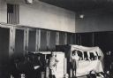
| Date: | 1944 |
|---|---|
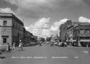
| Description: | View of intersection with pedestrians crossing the street in the town central business district. Businesses include three drugstores, a hotel, and a clothi... |
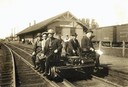
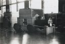
| Date: | 1908 |
|---|---|
| Description: | An early gasoline-powered handcar being used on the Minneapolis, St. Paul, & Sault Ste. Marie line for an inspection tour. The employees are (left to right... |
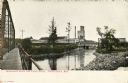
| Date: | 1910 |
|---|---|
| Description: | View from bridge looking towards the paper mill and railroad bridge on the Wisconsin River outside of Rhinelander. Caption reads: "Wisconsin River and Pape... |
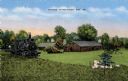
| Date: | 1920 |
|---|---|
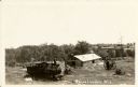
| Description: | Logging Museum in Rhinelander. Caption reads: "Museum, Rhinelander, Wis." |
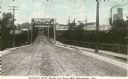
| Date: | 1905 |
|---|---|
| Description: | View down center of the Davenport Street Bridge with a paper mill in the distance on the right. Caption reads: "Davenport Street Bridge and Paper Mill, Rhi... |
| Date: | 1920 |
|---|---|
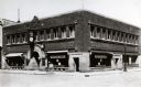
| Description: | Exterior view of First National Bank. There are signs in the windows for Western Union. |
| Date: | 08 1911 |
|---|---|
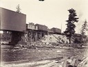
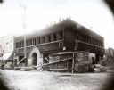
| Description: | Exterior view of First National Bank under construction. |
| Date: | 1905 |
|---|---|
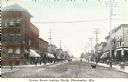
| Description: | Caption reads: "Brown Street looking North, Rhinelander, Wis." A dog is in the street, and pedestrians are on the sidewalks. |
| Date: | 1913 |
|---|---|
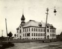
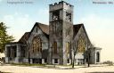
| Description: | Exterior view of a congregational church. Caption reads: "Congregational Church, Rhinelander, Wis." |
| Date: | 1939 |
|---|---|
| Description: | A group of students playing in their kindergarten classroom with a large train model. |
| Date: | 1939 |
|---|---|
| Description: | A large model of a train for students to play with in a kindergarten classroom. |

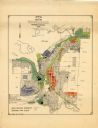
| Date: | 1915 |
|---|---|
| Description: | This 1915 map shows railroads, wagon roads, trails, creeks, rivers, lakes, and trout streams in Oneida and Lincoln counties within a 12 mile radius of Rhin... |
| Date: | 1956 |
|---|---|
| Description: | This map of Rhinelander shows lots, 6 types of zoning in various colors; heavy industry, light industry, commercial, residence "A," residence "unrated," lo... |

| Date: | 1900 |
|---|---|
| Description: | Photographic postcard of the James G. Dunn Grocery, with William John Dunn standing on the left and Maggie (O'Hare) Dunn on the right. Handwritten on the... |

| Date: | 01 1936 |
|---|---|
| Description: | Two large smokestacks rise from the 1903 building of the Rhinelander Paper Company. Railroad tracks are crossing the left foreground diagonally; a second s... |
If you didn't find the material you searched for, our Library Reference Staff can help.
Call our reference desk at 608-264-6535 or email us at: